O acidentado terreno das margens do rio Douro não permite a circulação de carros paralelamente ao rio. Assim, por regra, todas as vias na região assumem uma orientação norte-sul, aproveitando as lombadas das encostas que caiem para o rio, e cruzando este (por barca), ascendia na outra margem por nova lombada rumo à zona planáltica.
A imperativa necessidade de cruzar este grande rio da Península, em conjunto com a sua orografia particularmente difícil, moldou uma densa rede de vias norte-sul com inúmeros pontos de travessia não muito distantes entre si. Muitos dos estudos sobre viação antiga no Douro ignoram esta regra, sugerindo ligações paralelas ao rio que apesar de parecerem lógicas no mapa são inviáveis no terreno, com fortes pendente e difíceis travessias dos seus afluentes que se precipitam encosta abaixo para o rio Douro.
Os principais pontos de passagem do rio estão razoavelmente identificados, mas subsistiam muitas dúvidas no troço do rio que medeia entre Peso da Régua e terras de Numão. Os achados arqueológicos e alguns troços de via antiga apontavam para alguns nós viários importantes como Moimenta da Beira, Paredes da Beira, Penedono e São João da Pesqueira. No entanto, os trajectos finais destas vias continuavam incertos tanto para norte como para sul do rio. Deste modo, os achados que apontavam para a existência de um vicus viarum em cada um destes nós, permaneciam descontextualizados do ponto de vista viário.
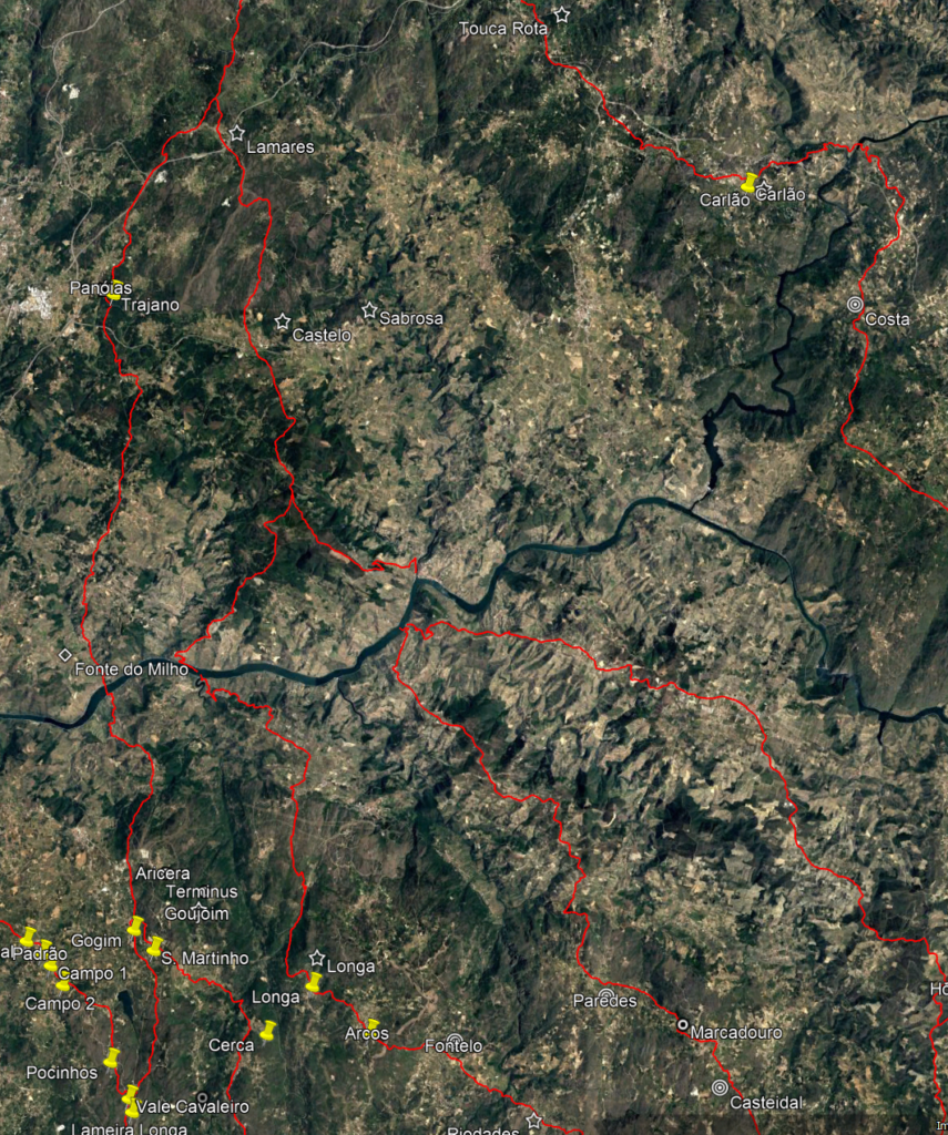
Uma via anteriormente identificada provinha de Chaves em direcção ao rio Douro passando na região mineira de Trêsminas e junto do Santuário de Panóias, cruzando o rio junto a Covelinhas. Seguia depois próximo do Castro de Goujoim rumo a Moimenta da Beira. Uma derivação desta estrada desviava em Campo de Jales para sudeste por Alto do Pópulo rumo à travessia do rio Tua junto das Caldas de Carlão. Daqui seguia para a travessia do Douro junto do povoado mineiro da Senhora da Ribeira, cruzando depois o território de Numão.
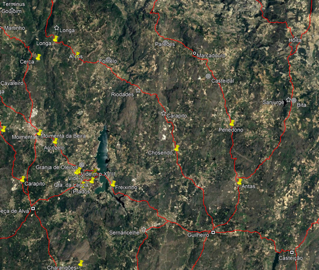
Havia suspeitas da existência de outras vias no espaço que medeia entre Covelinhas e Numão, nomeadamente a via que cruzava Paredes da Beira no concelho de São João da Pesqueira (onde se regista um povoado romano), e um outro troço que ligava as povoações de Longa e Riodades, no concelho de Tabuaço, passando no vicus de Fontelo.
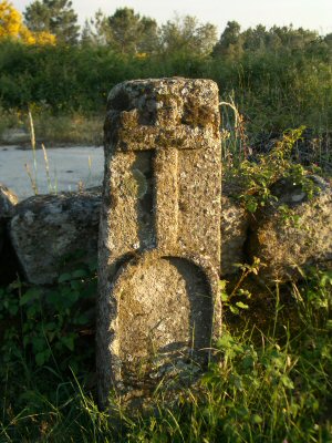
A recente identificação pelo arqueólogo José Carlos Santos de um possível miliário na povoação da Longa foi o factor que veio despoletar um novo estudo da rede viária na área que permitiu resolver finalmente as questões que permaneciam em aberto. Em concreto, toda a bibliografia consultada prolongava o troço da via este-oeste entre Arcos e Longa em direcção à travessia do rio Tedo, junto da actual povoação de Granja do Tejo. Na outra margem, temos o Castro de Coujoim e a via Chaves-Moimenta, sugerindo uma ligação entre estas duas vias.
As dúvidas que se mantinham sobre esta solução resultam das fortes pendentes da descida para o rio Tedo, portanto, incompatíveis com uma via para carros. A identificação do referido miliário em Longa permitiu finalmente esclarecer a questão. Desde logo, o achado de um miliário em Longa vem confirmar a existência de uma rota romana através deste caminho milenar.
Mas o detalhe que apontou em definitivo para a solução foi a informação precisa da sua localização que o colocava junto de um caminho de saída da aldeia para oeste, como seria expectável, sugerindo que estaria in situ (hipótese que se veio posteriormente a confirmar). No entanto, o referido caminho não se dirige para Granja do Tedo, mas para norte, inflectindo portanto o seu trajecto rumo ao rio Douro.
Estava assim levantada a forte possibilidade de o troço de via entre Longa e Arcos integrar uma grande rota romana. Seguindo o trajecto mais provável até ao Douro, verifica-se que a via se dirige à foz do rio Tedo (foz do rio Ceira na outra margem), local onde atravessava o rio Douro. Tal como neste caso, muitas das travessias do Douro são feitas junto da foz dos principais afluentes, evitando assim a necessidade de os cruzar próximo da sua confluência no Douro.
Medindo a distância entre a margem do rio e o marco que está em Longa, contam-se cerca de 12 milhas, mostrando que há acerto da contagem miliária, ainda por cima em torno do valor típico entre estações viárias e o rio, como por exemplo, no caso Panóias, também a 12 milhas do Douro. Resolvido o trajecto da via para norte, havia que estudar a sua continuação na direcção oposta.
Partindo da povoação Longa, seguia então o troço de via anteriormente cartografado, passando em Arcos e próximo do vicus do Fontelo em direcção a Riodades, onde cruzava o rio Távora. Daqui seguia por Carapito e Chosendo, onde recentemente apareceu um miliário epigrafado (FE 864, 2023). A via continuava até à povoação de Guilheiro, importante nó viário no planalto, onde se cruzavam diversas rotas da região da Beira Alta.
Depois de Guilheiro, a via continuava para sul por Queiriz e Muxagata (miliário na igreja) rumo à travessia do rio Mondego no sítio da actual Ponte de Juncais. Esta rota seguia depois por Carrapichana e Linhares, e daqui, cruzando a Serra da Estrela, atingia a estação viária de Centum Celas em Belmonte, entroncando na grande rota para Mérida por Igaeditana (Idanha-a-Velha), cruzando o rio Tejo na famosa Ponte Romana de Alcântara.
Em síntese, a descoberta do marco de Longa ainda in situ permitiu finalmente identificar esta grande rota que última análise ligava as importantes explorações mineiras da região Flaviense à capital da província, Emerita Augusta. Com efeito, ao prolongar a via para norte a partir do rio Douro, esta rota vai de encontro à via Chaves-Covelinhas referida acima, entroncando nesta junto do Castro de Lamares.
A identificação do trajecto desta rota, levou à resolução dos traçados prováveis de outras vias na região das quais apenas se tinha dados pontuais. De facto, tudo indica que existiam outras travessias do rio Douro a montante da passagem na foz do Tedo. Com efeito, foi também cartografada uma derivação da via que cruzava o Douro junto ao Pinhão, seguindo depois por Paredes da Beira, Penedono e Antas (estes últimos com possíveis miliários) rumo também ao nó viário de Guilheiro, evidenciando ainda mais a importância deste local como uma verdadeira encruzilhada de vias de toda esta região a sul do rio Douro.
Por fim, agradeço a José Carlos Santos a partilha do achamento destes marcos em resultado do seu aturado estudo da região, identificando e interpretando o imenso património arqueológico da região, que em geral continua praticamente desconhecido apesar de se encontrar numa zona turística por excelência como é a Região do Douro.
Ver mais detalhes nas entradas de Setembro e Outubro de 2023 do histórico de alterações em: https://viasromanas.pt/vrhist.html
Ver itinerários em:
https://viasromanas.pt/#tedo_guilheiro
https://viasromanas.pt/#selores_guilheiro
https://viasromanas.pt/#torto_belmonte
SANTOS, J. C. e ENCARNAÇÃO, J. d’ (2023a). Miliário em Chosendo, Sernancelhe. Ficheiro Epigráfico 255 (864).