Monthly Archives: February 2023

St. James’ Way and the ancient road system

The recent proliferation of the so called “Camino de Santiago” (St. James’ Way), although it has its merits, is creating a distorted vision of the ancient road system by tracing indiscriminate routes all over the country without a secure historical basis. Some care in the elaboration of these routes is thus required in order to reflect the true reality of the ancient paths, instead of trying to “force” a route that is hovering here and there, vaguely in the direction of Santiago, and that in most cases has nothing to do with the ancient roads that served this pillgrimage.

Of course, one can start from any geographical point and go to Santiago, but that does not mean that the path was used for that purpose. The route used by the pilgrims would certainly be the ancient routes inherited from the Roman period (but in reality with much older origins…), and apart from a few minor variations introduced over time, these routes remained practically unchanged until the 19th century, when it was necessary to build a new road network better adapted to motorised traffic.

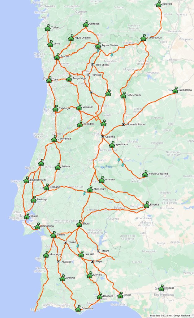
Now, for those departing from the current Portuguese territory, the two main access gates to Santiago would be Tui and Chaves. The first corresponds to the great S-N route from Lisbon which, like today, runs parallel to the coast passing through Santarém, Tomar, Coimbra and Porto, and then continues along the so-called “Central Way” via Barcelos to Valença. Naturally, for those coming from the Beiras region, the most direct route would be via Braga, continuing along the Bracara-Tudae road to Valença. This route aggregated various routes that crossed the River Douro respectively in Porto Antigo, Caldas de Aregos and Régua. From this last place, a route to Chaves run through the Sanctuary of Panóias and reached Chaves by crossing the heights of the Padrela Mountain, where it received another route also coming from another important crossing of the Douro River in Numão (Vesuvio/Ns. da Ribeira) that came through Carlão and Alto do Pópulo until it joined the Régua-Chaves axis near the important Roman mining exploitation of Trêsminas. From Chaves, the pilgrims would enter Galicia, heading towards Torre de Sandiás (Ourense), the station of Geminas mentioned in the XVIII Itinerary from Bracara to Asturica, an axis which crossed at this point, continuing from here to Santiago.

The prevalence of these ancient routes throughout the Middle Ages and even in much later periods makes it impossible to imagine that the route followed a “medieval route” to Santiago different from the one used in the Roman period, although here and there some variants have been introduced over the centuries. In this way, the map we present ends up being a panorama of the routes available for those who were heading to Santiago, which from any point quickly entered this ancient network of roads that practically covered whole the current Portuguese territory.
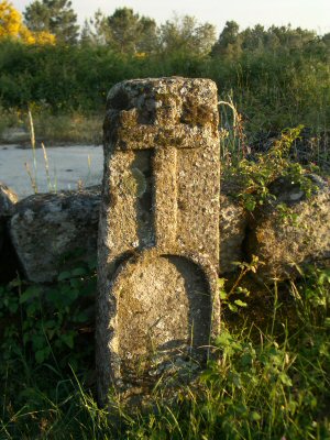
Milestone converted into Alminhas (shrine) near the Church of Ns. de Cervães (Mangualde)

The result is that although we are talking about different periods in time, the Roman and medieval roads are essentially the same physical reality. This can be seen as we travel along these roads because the great majority of the shrines, hermitages, crosses and landstones of the medieval period marking the passage of the way are positioned in accordance with the Roman mile of about 1500 m. In other words, even on the stretches where there are no milestones, it is possible to follow this marking every thousand steps which accompany the pilgrim along the route.
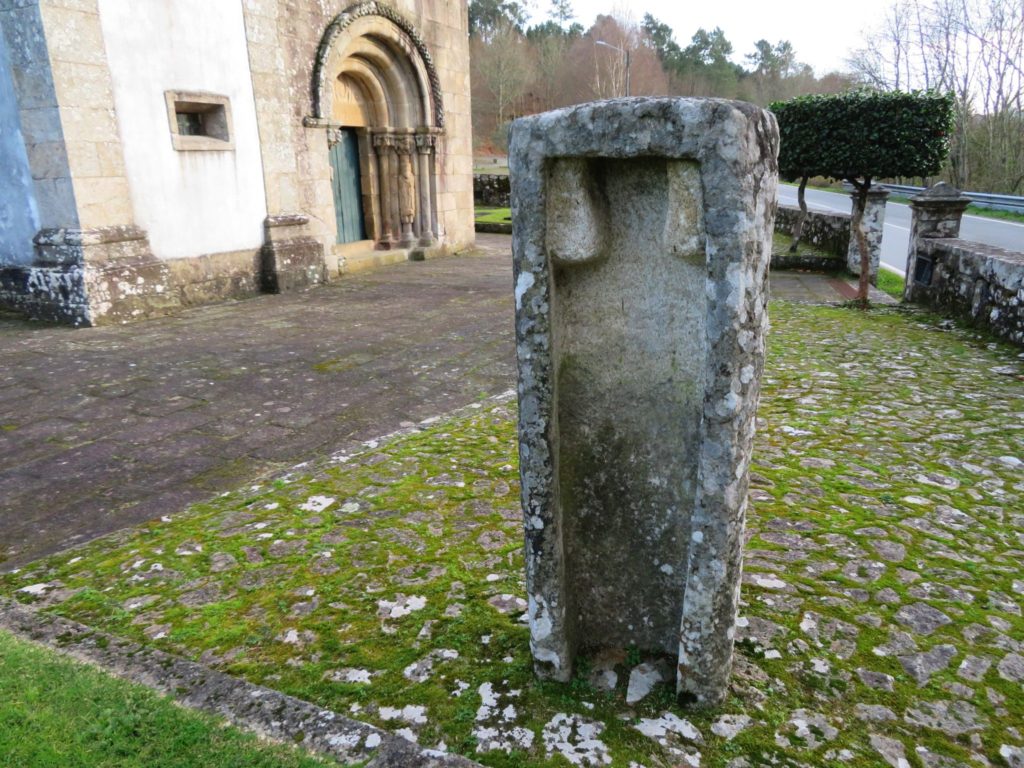
Milestone of Augustus on the courtyard of the Romanesque church of Rubiães, converted into a sarcophagus.

The historical density and typology of these routes has nothing to do with this multiplicity of routes that have been created towards Santiago, distorting the historical reality, taking the pilgrim away from the true immersive experience that these historical routes provide.

February 2023

“Caminhos de Santiago” e a rede viária antiga

A recente proliferação dos chamados «Caminhos de Santiago», ainda que tenha os seus méritos, está a criar uma visão distorcida da viação antiga ao traçar percursos indiscriminados um pouco por todo o país sem bases históricas seguras. Seria necessário ter algum cuidado na elaboração destes percursos de modo a reflectir a verdadeira realidade da viação antiga, em vez de “forçar” um percurso que vai atalhando por aqui e acolá, vagamente em direcção a Santiago, e que na maioria da vezes nada têm de antigo.

Claro que se pode partir de qualquer ponto geográfico e seguir para Santiago, mas isso não significa que o caminho fosse utilizado para esse fim. O caminho utilizado pelos peregrinos seria seguramente pelas velhas vias herdadas do período romano (mas na realidade com origens bem mais antigas…), sendo que para além de umas pequenas variantes introduzidas ao longo dos tempos, estas rotas mantiveram-se praticamente inalterados até ao século XIX, momento a partir do qual foi necessária construir uma nova rede de estradas mais adaptada ao trânsito motorizado.

Ora, para quem partia do actual território português, as duas principais portas de acesso a Santiago seriam Tui e Chaves. A primeira corresponde à grande rota S-N oriunda de Lisboa que tal como hoje seguia paralela à costa passando por Santarém, Tomar, Coimbra e Porto, continuando depois pelo chamado «Caminho Central» por Barcelos até Valença. Naturalmente que para vinha das Beiras o caminho mais directo seria via Braga, continuando pela via Bracara-Tudae até Valença. Este eixo viário, agregava várias rotas que cruzavam o Rio Douro respectivamente em Porto Antigo, Caldas de Aregos e Régua. Deste último local partia uma via rumo a Chaves passando junto do Santuário de Panóias e cruzando depois por alturas da Serra da Padrela, onde recebia uma uma outra via também proveniente de outro importante cruzamento do Rio Douro em Numão (Vesúvio/Ns. da Ribeira) que vinha por Carlão e Alto do Pópulo até reunir com o eixo Régua-Chaves junto da importante exploração mineira romana de Trêsminas. A partir de Chaves, os peregrinos entravam na Galiza, seguindo na direcção de Torre de Sandiás (Ourense), a estação de Geminas referida no Itinerário XVIII de Bracara a Asturica, eixo que cruzava neste ponto, continuando daqui para Santiago.

A prevalência destes trajectos antigos por toda a Idade Média e mesmo em períodos bem posteriores, inviabiliza a hipótese de o caminho seguir uma “via medieval” para Santiago diferente da utilizada no período romano, apesar de aqui ou ali terem sido introduzidas algumas variantes ao longo dos séculos. Deste modo, o mapa que apresentamos acaba por ser panorama das rotas disponíveis para quem se dirigia para Santiago, que partindo de qualquer ponto rapidamente entrava na rede geral antiga pois esta cobria praticamente a totalidade do actual território português.

Miliário convertido em Alminhas junto da Igreja de Ns. de Cervães (Mangualde)

Daqui resulta que apesar de estarmos a falar de diferentes momentos temporais, o caminho romano e medieval é no essencial a mesma realidade física. Isso mesmo se verifica ao percorrer estes eixos viários pois a grande maioria das alminhas, ermidas, cruzeiros e marcos divisórios do período medieval assinalando a passagem da via estão posicionados em concordância com a marcação miliária de 1500 m, ou seja com a chamada “milha romana”. Ou seja, mesmo nos troços onde não há miliários, é possível seguir a marcação de mil em mil passos através desses marcadores da estrada que acompanham o peregrino ao longo do trajecto.

Miliário no adro da Igreja Românica de Rubiães reconvertido em sarcófago no período Medieval

A densidade histórica e tipologia destes percursos nada tem a ver com esta multiplicidade de percursos que têm sido criados rumo a Santiago, distorcendo a realidade histórica, tirando o peregrino da verdadeira experiência imersiva que estes caminhos históricos proporcionam.

What’s a “roman road” afterall?

When we started this project in 2004, the idea was to compile the available knowledge about Roman roads in Portugal and make it accessible to everyone. Now, the best way to do that would be to publish online travel routes covering these routes, following the initial spirit of the so-called “Itinerary of Antoninus”, an essential document for the identification of Roman routes, even because at the time there was practically nothing online on the subject.

It quickly became clear that the study of the Roman road network remained buried in a mire of conjecture and great doubts not only about the route followed by the road as well as the location of the stations mentioned in the Itinerary, which actually take us to a pre-Roman reality, a fact evidenced by the large number of indigenous toponyms listed in the document as road stations (the vast majority), and in all cases we can associate then with Iron Age settlements, commonly called “castros”.

Most likely the document has its origins in the military conquest and subsequent civil wars, ending up fixing the main routes that interconnected the strategic centres, but essentially using the same routes of the Iron Age. The aim was naturally to keep control over the traffic circulating along those axes, but above all, a way to control the access to the enormous metalliferous wealth that characterises the Iberian Peninsula, whose economic value would have been the main factor behind the Roman conquest.

The following development is thus in part the continuity of that pre-Roman reality, reflecting the settlement model adopted during the Iron Age, characterised by the installation of settlements near the road axes, forcing the fortification of these settlements with thick walls, as opposed to the previous period, the Bronze Age, where preference was given to settlements on mountain peaks, far from the road and protected from potential enemies, thus dispensing with the construction of a walled enclosure. It is obviously a general framework with several exceptions.

Consequently, the so-called “Roman road” is invariably based on ancient routes of the Iron Age, but receiving many upgrades that provided a better transitability that never existed before. Thus, it would be more correct to speak of “ancient roads” than “Roman roads” since it was not exactly the Romans who designed and built the road. On the other hand, the Roman geo-strategic vision was one of maximum economic exploitation and what mattered was to ensure that the Imperial power had control of the main mining exploitations.

This is also reflected in the epigraphy related to the exploitations of Las Medulas (Ponferrada, León) and Tresminas (Vila Pouca de Aguiar), attesting in both cases a direct administrtion by the Imperial power. In fact, the strong investment carried out in the roads that departed from Braga throughout the Imperial period is the reflex of this need to control this vast mining region that extends until Asturica (today Astorga), fact that is reflected in the great number of milestones of different emperors registered in these roads that connected the heads of the convents Lucencis (Lugo), Bracarensis (Braga) and Asturicensis (Astorga).

Apart from these roads, which are exceptional even in the Roman context, all the others have only a few milestones, much more spaced, marking important points of the route, namely road stations. The existence of remains of structures attributable to the Roman period in these locations indicate the presence of a road establishment to support travelers. This more spaced marking compared to the northwestern peninsular routes is reflected in the smaller number of known milestones south of the Douro. For example, in the Algarve, one of the most “Romanised” regions of the country, only one milestone is known, and even this one has singular characteristics that set it apart from the others found in Portugal.

The other relevant aspect in the interpretation of the itineraries is that it is not a compilation of routes as it has been claimed (in fact, the designation “Vias” was applied in one of the medieval copies, as well as the numbering), but instead these are itineraries, interconnecting the maximum number of relevant points, providing the travellers with a summary of the main routes and the respective intermediate distances. Thus when it is said that there were three ways to Merida, one through Évora, another one through Alter do Chão and another one closer to the Tagus (the so called Via XII, XIV and XV, respectively), we don’t really have three ways to Merida, but three different itineraries, which use independent stretches of roads, forming a great route.

In fact, everything indicates that the main route would be the variant through Alter do Chão, both because it is the shortest route and because it has received several improvements, including the construction of major engineering works such as the Roman bridge of Vila Formosa. Thus, everything indicates that this would be the great route that linked Mérida to the Tejo River, forming a route with caput viae in Santarém and Mérida.

The choice of Mérida for capital of the Lusitânia is surely related with the crossing here of the Guadiana, being therefore this way that allowed the shortest connection of Mérida to the sea, linking this crossing of the Guadiana to the mouth of the Tejo River.

The foundation of Portugal as independent nation and the consequent border disputes with the Kingdom of Spain eventually dictated the slowing down of some of the great trade routes of antiquity, but apart from these forced changes, the Roman road network remained in use for centuries to come and contrary to what has been said it did not completely disappear from the landscape (following the old myth that all Roman roads were paved), but remains in use now as municipal roads or agricultural paths, despite the attacks it has suffered during the last century.

On the contrary, what we see on the ground is a great resilience of these millenary paths, whether they are transformed into modern roads or as almost imperceptible paths on the top of the mountains. Their natural, patrimonial and historical value will eventually come to the surface, which will induce a rehabilitation of these paths, creating an alternative future for these paths that can take them out of the current oblivion.

Map of the main Roman roads in Portugal and respective stations (@pedro.soutinho)