Monthly Archives: August 2021

The ancient road of Lomba do Mouro

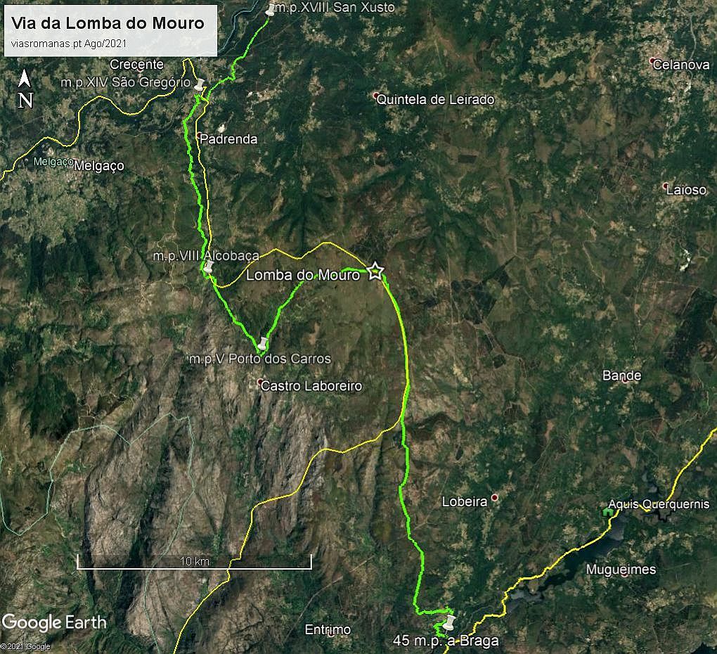
With regards to the current excavation at the Roman military camp of Lomba do Mouro (Castro Laboreiro), whose preliminary results point to the conquest period of the peninsular northwest (video), I tried to identify the possible route of the track that crossed the Roman camp, situated on the heights of the Laboreiro mountain range, present-day Galicia/Portugal border (apparently absent from the scientific literature). In fact, if we extend the track southwards, following the mountain’s festo line, we will find the new track, crossing the Lima river near the village of Torno (Lóbios). This route would be a northern derivation of the via nova between Bracara and Asturica, crossing the Lima at a meander of the river called Retorta, 45 miles away from Braga. It then ascended the slope up to the Ermida de San Benito (perhaps through Lama and Ferreiros), continuing afterwards through the Serra de Laboreiro up to the Roman camp, making up 13 miles from the Lima, the usual distance between road stations.

Fig. 1 – The Lomba do Mouro camp on the Luso-Spanish border (yellow line), walled enclosure and possible track layout (elaborated on Google Earth); distances to the Minho River (São Gregório, to the north) and the Lima River (Retorta, to the south). The light areas inside the enclosure correspond to previously excavated megalithic funerary monuments.

The compound still bears the remains of its 2.2 m thick wall, enclosing an area of over 20 hectares (Costa-García, Fonte and Gago, 2019: 33). The existence of this camp implies that the route would have continued to Galicia, but its route northwards from the camp does not seem feasible, presenting a very rugged terrain, where passage is very difficult. Thus, it is more likely that the track would have made an inflection towards Castro Laboreiro (perhaps through Alto da Picota, Queimadelo, Falagueiras, Coriscadas e Porto de Carros), and from there going north again, through Porto de Asnos and through the valley of the Trancoso River to São Gregório, where it entered Galicia. Its route should correspond to the path which passes through the road names Vido, Portelinha and Porteiro or Porto de Cavaleiros (former “Porto de Asnos”), continuing through Alcobaça, A-da-Velha, Campo do Souto, Sobreira and Cristoval as far as São Gregório, going down from here to cross the Trancoso river at the so-called Ponte Velha or Ponte Barxas, an ancient entrance gate into Galician territory. The route could then follow alongside the toponym Vendas towards the Ermida de San Xusto (Trado), 18 miles from Lomba do Mouro, possibly heading towards Ourense, but its final destination is still uncertain.

Fig. 2 – The Roman camp of Lomba do Mouro (in García, Fonte and Gago, 2019: 33)

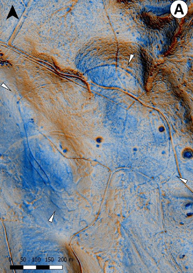
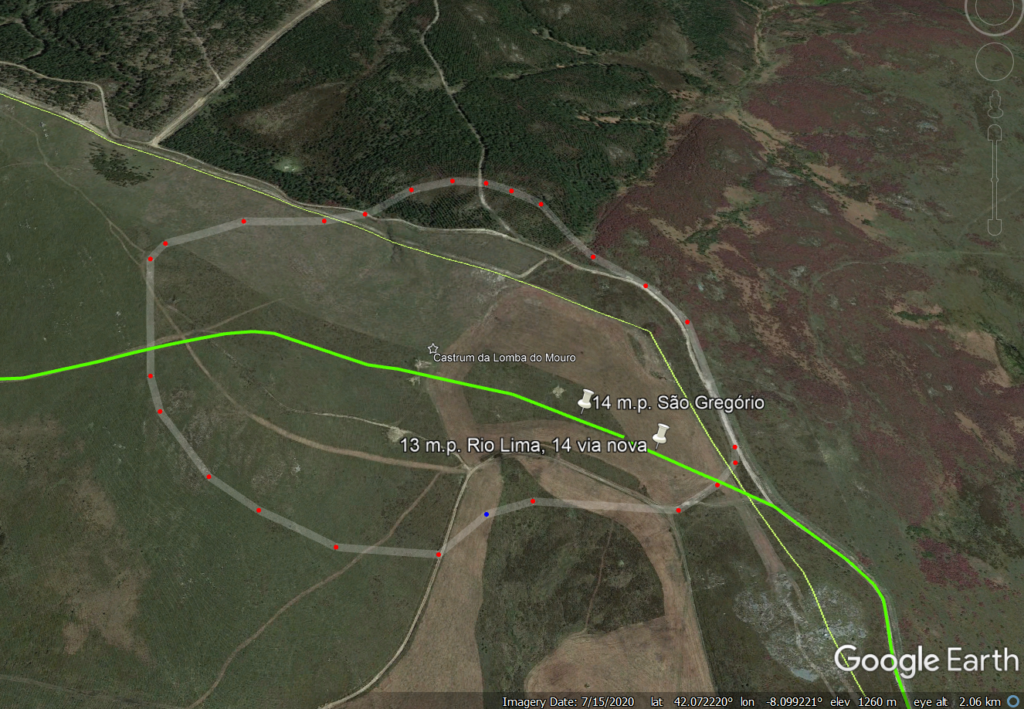
The strategic importance of this penetration route for the Roman armies of the initial phase of the conquest seems to be attested by the great size of the military enclosure, almost totally surrounded by a solid wall, which could only be justified for a route of the greatest military importance. Its location, halfway between the Lima and Minho rivers (13 miles to the Lima and 14 to São Gregório), allowed it to exert total control over this passage.

Although some authors felt that there should be a northward derivation of the new route, its layout continued to raise many doubts. The identification and characterisation of this important military settlement thus provides a strong argument for the identification of this road axis and its articulation with the major routes in the region.

Fig. 3 – Hypothetical track layout (green line) deriving from the ‘new track’ to the north (yellow line), passing through Castrum da Lomba do Mouro, then descending towards Castro Laboreiro to take the old entry route to Galicia via Porto de Asnos and Ponte Velha de São Gregório (elaborated on Google Earth, 2021)

There doesn’t seem to be any doubt about the antiquity of this path, given that the Roman settlement sits on a vast field covered with megalithic funerary monuments that testify to its use since very early times. Despite the abandonment of the camp after the conquest of this territory, the track would have remained in use until the high-medieval period, during which the dividing line between Portugal and the current Galician territory was formed. The fact that the route crossed both sides of this division may have contributed to its decline, as it was now cut by the border line.

The “Portuguese” part, connecting Castro Laboreiro to São Gregório, through the referred
“Porto de Asnos” remains in use as the main entrance to Galicia, as referred to in various medieval documents, and is considered a strategic passage for the defence of the Entre Lima and Minho territory. Following a tax dispute with the neighbouring Castle of Melgaço, this stretch of the road was closed to traffic in 1361, forcing all travellers to go to and from Galicia via Melgaço, which also contributed to its oblivion:

“To avoid paying this toll, merchants who carried their goods from Galicia, and vice versa, opted for the passage of the Porto dos Asnos, joint place of the parishes of Lamas de Mouro and Castro Laboreiro. To avoid this tax evasion, by letter written in Elvas, on 28th May 1361, D. Pedro I forbade this path, forcing the merchants to pass through Melgaço”. (in Domingues, 2003: 11)

The growing disuse of this route may have contributed to its relative oblivion in the context of Roman roads, but identification of what seems to be “the largest and oldest” Roman military camp between the 2nd and 1st centuries BC. (Costa-García, Fonte and Gago, 2019: 33), located precisely halfway between the rivers Lima and Minho, constitutes a strong argument to validate the existence from this route that was surely one of the lines of penetration lines of the Roman army during the period of conquest in the northwest of the Iberian Peninsula.

Bibliography:

COSTA-GARCÍA, J.M.; FONTE, J.; GAGO, M.; (2019) – “The reassessment of the Roman military presence in Galicia and Northern Portugal through digital tools: archaeological diversity and historical problems”, Mediterranean Archaeology and Archaeometry 19, 3, (2019), p. 17-49 https://zenodo.org/record/3457524

DOMINGUES, José (2003) – “O Foral de D. Afonso Henriques a Castro Laboreiro. “Ádito” para o debate”. Porto, 2003, [placed online 6 May 2013].
http://www.academia.edu/3470740

romanarmy.eu – Collective research on the Roman military presence in the northwest Iberian Peninsula https://www.youtube.com/watch?v=fXGZVPHf3Oc&ab_channel=romanarmy.eu

A via antiga da Lomba do Mouro

A propósito da escavação em curso no acampamento militar romano da Lomba do Mouro (Castro Laboreiro), cujos resultados preliminares apontam para o período inicial da conquista do noroeste peninsular (video), tentei identificar o possível traçado da via que cruzava o acampamento romano, situado nas alturas da Serra de Laboreiro, actual fronteira Galiza/Portugal (aparentemente ausente da literatura científica). De facto, se perlongarmos a via para sul percorrendo a linha de festo da serra vamos de encontro à via nova, cruzando o rio Lima próximo da povoação de Torno (Lóbios). Este trajecto seria assim uma derivação para norte da via nova entre Bracara e Asturica, cruzando o Lima num meandro do rio designado por Retorta que dista cerca de 45 milhas de Braga. Ascendia depois a encosta até à Ermida de San Benito (talvez por Lama e Ferreiros), continuando depois por alturas da Serra de Laboreiro até ao acampamento romano, perfazendo 13 milhas desde o Lima, distância habitual entre estações viárias.

Fig. 1 – O acampamento da Lomba do Mouro na fronteira luso-espanhola (linha amarela), recinto amuralhado e possível traçado da via (elaborado sobre Google Earth); distâncias ao Rio Minho (São Gregório, a norte) e ao Rio Lima (Retorta, a sul). As áreas claras no interior do recinto correspondem a monumentos funerários megalíticos anteriormente escavados.

O campo ostenta ainda os vestígios da sua muralha com 2,2 m de espessura, cercando uma área com mais de 20 hectares (Costa-García, Fonte e Gago, 2019: 33). A existência deste acampamento implica que a via teria continuação para a Galiza, mas o seu percurso para norte a partir do acampamento não parece ser viável, apresentando um terreno muito acidentado, onde a passagem se apresenta muito dificultada. Deste modo, é mais provável que a via fizesse uma inflexão rumo a Castro Laboreiro (por Alto da Picota, Queimadelo, Falagueiras, Coriscadas e Porto de Carros), para daqui retomar a direcção norte que trazia do rio Lima, seguindo por Porteiro (antigo «Porto de Asnos») e pelo vale do rio Trancoso até São Gregório, onde entrava na Galiza. O seu traçado deverá corresponder ao caminho que passa nos topónimos viários Vido, Portelinha e Porteiro ou Porto de Cavaleiros (antigo «Porto de Asnos»), continuando por Alcobaça, A-da-Velha, Campo do Souto, Sobreira e Cristoval até São Gregório, descendo daqui para cruzar o rio Trancoso na chamada Ponte Velha ou Ponte Barxas, antiga porta de entrada no território Galego. Na continuação, a via poderia seguir junto do topónimo Vendas em direcção à Ermida de San Xusto (Trado), local a cerca de 18 milhas da Lomba do Mouro, possivelmente rumo a Ourense, mas o seu destino final é ainda incerto.

Fig. 2 – O acampamento romano da Lomba do Mouro (in García, Fonte e Gago, 2019: 33)

A importância estratégica desta via de penetração dos exércitos romanos da fase inicial da conquista parece atestada pela grande dimensão do recinto militar, cercado quase na totalidade por uma sólida muralha que só teria justificação para uma via da maior importância militar. A sua localização, a meio caminho entre os rios Lima e Minho (cerca de 13 milhas ao Lima e cerca de 14 a São Gregório), permitia-lhe exercer total controlo desta passagem.

Embora fosse pressentido por alguns autores que deveria existir uma derivação da via nova para norte, o seu traçado continuava a levantar muitas dúvidas. A identificação e caracterização deste importante assentamento militar vem assim trazer um forte argumento para a identificação deste eixo viário e a sua articulação com os grandes itinerários da região.

Fig. 3 – Traçado hipotético da via (linha verde) derivando da ‘via nova’ para norte (linha amarela), passando na Castrum da Lomba do Mouro, descendo depois rumo a Castro Laboreiro para tomar o antigo caminho de entrada na Galiza por Porto de Asnos e Ponte Velha de São Gregório (elaborado sobre Google Earth, 2021)

Não parece haver qualquer dúvida sobre a antiguidade deste caminho, dado que o acampamento romano assenta sobre um vasto campo coberto de monumentos funerários megalíticos que testemunham a sua utilização desde tempos bem recuados. Apesar do abandono do recinto após a conquista deste território, a via terá permanecido em utilização até ao período alto-medieval, durante no qual se foi formando a linha divisória entre Portugal e o actual território Galego. O facto de a via percorrer ambos os lados desta divisória poderá ter contribuído para o seu declínio dado que estava agora cortada pela linha fronteiriça.

A parte “portuguesa”, ligando Castro Laboreiro a São Gregório, pelo referido
«Porto de Asnos» continua em utilização como principal porta de entrada na Galiza, tal como é referido em vários documentos medievais, sendo considerada uma passagem estratégica para a defesa do território de Entre Lima e Minho. Na sequência de uma disputa tributária com o vizinho Castelo de Melgaço, este troço da via acaba sendo vedado ao trânsito em 1361, obrigando que todos os viandantes de e para a Galiza seguissem por Melgaço, o que também terá contribuído para o seu esquecimento:

“Para evitar o pagamento dessa portagem, os mercadores que acarretavam os seus bens de Galiza, e vice-versa, optavam pela passagem do Porto dos Asnos, lugar meeiro das freguesias de Lamas de Mouro e Castro Laboreiro. Para evitar essa evasão fiscal, por carta passada em Elvas, aos 28 de Maio de 1361, D. Pedro I interdita esse caminho, obrigando os mercadores a passar por Melgaço.” (Domingues, 2003: 11)

A crescente inutilização deste eixo viário poderá ter contribuído assim para o seu relativo esquecimento no contexto da viação romana, mas identificação do que parece ser “o maior e mais antigo” acampamento militar romano entre os séculos II e I a.C. (Costa-García, Fonte e Gago, 2019: 33), localizado precisamente a meio caminho entre os rios Lima e Minho, constitui um argumento de peso para validar a existência desta via que terá sido como tudo indica uma das principais linhas de penetração das hostes romanas durante o período da conquista do noroeste peninsular.

Bibliografia:

COSTA-GARCÍA, J.M.; FONTE, J.; GAGO, M.; (2019) – “The reassessment of the Roman military presence in Galicia and Northern Portugal through digital tools: archaeological diversity and historical problems”, Mediterranean Archaeology and Archaeometry 19, 3, (2019), p. 17-49 (https://zenodo.org/record/3457524)

COSTA-GARCÍA, J.M.; FONTE, J.; GAGO, M.; (2019) – “A reavaliação da presença militar romana na Galiza e no Norte de Portugal através de ferramentas digitais: diversidade arqueológica e problemas históricos”. Mediterranean Archaeology and Archaeometry 20 (2019)
(https://minerva.usc.es/xmlui/bitstream/handle/10347/19902/maa_resumo_pt.pdf)

DOMINGUES, José (2003) – “O Foral de D. Afonso Henriques a Castro Laboreiro. «Ádito» para o debate”. Porto, 2003, [colocado em linha a 6 de Maio de 2013]
http://www.academia.edu/3470740

romanarmy.eu – Coletivo de investigação sobre a presença militar romana no noroeste da Península Ibérica https://www.youtube.com/channel/UCpPG7vsTY5lpghKHcxXoRFg