Tag Archives: ponte

A bridge over the Douro River: a failed project

In 1179, the first king of Portugal, Dom Afonso Henriques, stipulated the delivery of 300 modios morabitinos for the “Ponti Dorii”, launching the project to build a bridge over the River Douro. The remains of this bridge were still visible in the 16th century when Rui Fernandes wrote his manuscript entitled “Descrição do terreno ao redor de Lamego duas léguas [ 1531-1532 ]“, currently in the Municipal Library of Porto, which reads:

Item between this ferryboat of Bernaldo, and that of Porto de Rey are some fine pillars of a bridge that the Queen Donna Mafalda say she ordered to be made, which are two in the middle of the Douro of very great height, and very wide foundation, that the two that are in the river, in this month of May will be ten palms uncovered, and in the summer will be twenty palms and more, and there are two others outside, one on this side, and another on the other side. These pillars have already been doubled in height, and they broke them down and make fishing grounds out of them” (translation of ms. 547, fl 9).

The pillars of the old bridge were therefore still very visible in his time, although they had already been heavily collapsed: “The arch on one side has already collapsed. There is much broken stone on the hill, and you will find on the hills many mason stone tools, and wedges, and levers, which were left there” (fl. 9).

He also calls for taxes to be levied on the neighboring villages in order to complete the work, “because the majority of it has been done” and because there was still a lot of “broken stone” ready to be used to complete the work:

“Our Lord the King could very well order this half bridge to be built with the payment of two reis to each inhabitant twenty leagues around, and in six or seven years, or less, it could be done without oppression, and it would be a very noble thing” (fl. 9).

However, the work would never be finalized and what remains of these pillars were submerged after the construction of the Carrapatelo dam in 1972, but there are reports from that time mentioning the remains of one of the pillars in the riverbed (Resende. 2014: 423).

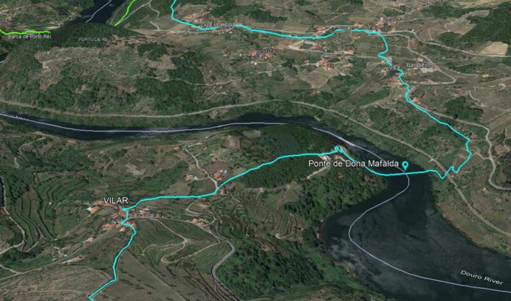
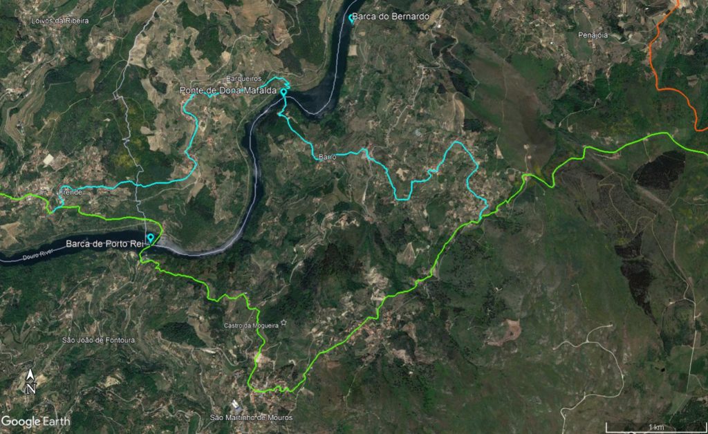
Moreover, we have precise information from the fifteenth-century author about its location when he writes that “this work is below a place, that they call Barqueiros moreover that they call Barrô” (fl.  9v), about 18 km from Porto Manso (“from Peares to Porto Manço there are three leagues“, fl. 10), which allows us to estimate its approximate location in the meander of the river between Barqueiros and Barrô, where the riverbanks are narrower (see image).

Approximate location of the Dona Mafalda Bridge, between Barqueiros and Barrô, upstream of the Porto de Rei ferry (over Google Earth image)

Although Rui Fernandes alludes to the legend of the death of the queen’s son when trying to cross the bridge, justifying this way the abandonment of its construction, we cannot exclude the hypothesis that it was finished and that its destruction was later, possibly due to a flood of the river, not least because the chosen location does not seem to be the most suitable for the construction of a bridge, the Douro being such a tumultuous river, and even less so the accesses to the bridge that would have to overcome the steep cliffs from this location.

In his “Elucidário…”, Friar Rosa Viterbo seems to follow this line by referring to documents from the Salzedas Monastery of 1205 containing the will of Dona Sancha Bermudes where it says that she had an estate “at the Douro Bridge”, as well as in another document from 1216, where she donates to the Monastery of Paço de Sousa everything she owned in Barrô and “near the Douro Bridge” (Viterbo, 1799: 227). Thus, it is possible that the bridge was still operational in that period, as Viterbo suggests, serving as an alternative to crossing the Douro at Porto de Rei from the road that connected Marco de Canaveses to Lamego (see https://viasromanas.pt/index.html#porto_de_rei_lamego).

The route from Porto de Rei to Lamego (green) and its variant passing on the Dona Mafalda Bridge (blue)

What is certain is that the dream of building a bridge over the Douro River ended in ruin, and until the 19th century all crossings of the river were provided by ferries. The medieval Douro bridge was a failed project whose implications were felt for many years, and even today there is stil no bridge in the stetch of the river between Régua and Resende, and the new Ermida Bridge, near the latter, was only inaugurated in 1998!

_______________________________________

Bibliography
FERNANDES, Rui (1531-1532) – “Descrição do terreno ao redor de Lamego duas léguas [ 1531-1532 ]“. Caleidoscopio, Ed. Amândio Barros (2012).
RESENDE, Nuno (2008) – “Ponte da Veiga: Lousada“. In ROSAS, Lúcia, coord. cient. – Rota do Românico, 2014. Vol. 2, 419-431.
VITERBO, Frei Joaquim de Santa Rosa de (1799) – “Elucidário das Palavras Termos e Frases”(…). Lisboa: Typographia Regia Silviana (1º Edição), vol. 2.

Ponte do Douro: um projecto falhado

Em 1179, o primeiro rei de Portugal, Dom Afonso Henriques estipulou a entrega de “300 modios morabitinos para a ponti Dorii”, lançando o projecto de construção de uma ponte sobre o rio Douro. Os restos dessa ponte eram ainda visíveis no século XVI quando Rui Fernandes elabora o seu manuscrito intitulado “Descrição do terreno ao redor de Lamego duas léguas [ 1531-1532 ]“, actualmente na Biblioteca Municipal do Porto, onde se lê:

Item entre esta barca do Bernaldo, e a de Porto de Rey estão huns fermozos peares de hua ponte que a Rainha Donna Mafalda dizem que mandava fazer os quais sam dois no meyo do Douro de muito grande altura, e mui largo fundamento, que os dous que estão no rio, neste mes de Mayo hirão bem dez palmos descobertos, e no Verão hirão bem vinte palmos e mais, e estão outros dous de fora hum da parte daquem, e outro da parte dalem. Estes poyares foram já de dobrada altura, e os derribarão, e fizerão delles pesqueiras” (ms. 547, fl. 9).

Estes “peares”, ou seja os pilares da antiga ponte estavam portanto ainda bem visíveis no seu tempo, embora já muito derrubados: “O arco da parte daquem volvia já. Esta hi muita pedra quebrada polo monte, que ficou quebrada, e acharão ainda polos montes muitas marras, e cunhas, e lavancas, que por hi ficarão” (fl. 9).

Apela também para que se lance impostos sobre as povoações vizinhas de modo a concluir a obra, “porque a mor parte hé feito” e porque ainda existia ali muita “pedra quebrada” pronta a usar na finalização da obra:

El Rey nosso senhor podia mui bem mandar fazer esta meya ponte que esta por fazer com deitar des reis a cada morador vinte legoas arredor, e em seis, ou sete annos, ou em menos se podia fazer sem opressão, e seria hua couza mui nobre” (fl. 9).

No entanto, a obra jamais sería concluída e o que resta desses pilares ficou submerso após a construção da barragem do Carrapatelo em 1972, mas há relatos dessa época onde se referem os restos de um dos pilares no leito do rio (Resende. 2014: 423).

Apesar disso, temos informações precisas do autor quinhentista sobre a sua localização ao escrever que “esta obra esta abaixo de hum lugar, que chamão Barqueiros aliás que chamão Barrô” (fl. 9v), a cerca de 18 km de Porto Manso (“des os Peares ate Porto Manço que são tres legoas“, fl. 10), o que permite estimar a sua localização aproximada no meandro do rio entre Barqueiros e Barrô, onde a proximidade entre margens é menor (ver imagem).

Localização aproximada da Ponte de Dona Mafalda, entre Barqueiros e Barrô, a montante da Barca de Porto de Rei (sobre imagem Google Earth)

Apesar de Rui Fernandes aludir à lenda da morte do filho da rainha neste mesmo local para justificar o abandono da sua construção, não podemos excluir a hipótese de a mesma ter sido finalizada e que a sua destruição seja posterior, eventualmente devido a uma cheia do rio, até por que o local escolhido não parece ser o mais indicado para a construção de uma ponte, sendo o Douro um rio tão tumultuoso, e menos ainda os acessos à ponte que teriam de vencer as íngremes arribas desde local.

No seu “Elucidário…”, o frei Rosa Viterbo parece seguir esta linha ao referir documentos do Mosteiro de Salzedas do 1205 contendo o testamento de Dona Sancha Bermudes onde diz que esta tinha uma herdade “à Ponte do Douro”, assim como em outro documento de 1216, onde faz a doação ao Mosteiro de Paço de Sousa do tudo o que detinha em Barrô e “junto da Ponte do Douro” (Viterbo, 1799: 227). Deste modo, é possível que a ponte estivesse operacional nesse período, como sugere Viterbo, servindo como alternativa à travessia do Douro em Porto de Rei da estrada que ligava Marco de Canaveses a Lamego (ver https://viasromanas.pt/index.html#porto_de_rei_lamego).

A via de Porto de Rei a Lamego (verde) e a variante pela Ponte de Dona Mafalda (azul)

Certo é que o sonho de construir uma ponte sobre o rio Douro acabou em ruína e até ao século XIX todas as travessias do rio foram asseguradas por barcas de passagem. A ponte medieval do Douro foi um projecto falhado cujas implicações fizeram-se sentir por muitos e longos anos, e ainda hoje não existe qualquer ponte a ligar as duas margens no trecho entre a Régua e Resende, e mesmo a Ponte da Ermida, junto a esta última povoação, apenas foi inaugurada quando decorria já o ano de 1998!

______________________

Bibliografia
FERNANDES, Rui (1531-1532) – “Descrição do terreno ao redor de Lamego duas léguas [ 1531-1532 ]“. Caleidoscopio, Ed. Amândio Barros (2012).
RESENDE, Nuno (2008) – “Ponte da Veiga: Lousada“. In ROSAS, Lúcia, coord. cient. – Rota do Românico, 2014. Vol. 2, 419-431.
VITERBO, Frei Joaquim de Santa Rosa de (1799) – “Elucidário das Palavras Termos e Frases”(…). Lisboa: Typographia Regia Silviana (1º Edição), vol. 2.


Roman bridge in Torre de Dona Chama

An initiative of the “Dona Flâmula”, an association for the protection of the heritage of Torre de Dona Chama, in collaboration with the Freguesia of Torre de Dona Chama and the Municipality of Mirandela, the Roman bridge over the Tuela River has finally now an informative plaque (since June 2020) describing the importance of the almost forgotten National Monument. Here are some photos kindly sent by António Reimão.

This bridge also known as “Ponte da Pedra” is one the best preserved Roman bridges in the Portuguese territory and it still use today by the national road EN 206 (!).

Ficheiro:Ponte Torre Dona Chama Vista jusante margem direita.jpg
View o the arches
The holes to grab and place stones using a forfex.