This itinerary from Braga to Astorga (Via XVIII of the Itinerary of Antonino) integrates one of the best preserved stretches of the route in Portugal, crossing the Serra do Gerês (where it is called “Geira”), heading towards Galicia through Portela do Homem. The Portuguese part is relatively well studied, with a consolidated route based on the great number of existing milestones, but in the Spanish part there are still great uncertainties, both in the actual route chosen and the location of the intermediate stations. In the attempt to clarify the route to Astorga, and applying the methods developed for the survey of the Portuguese part, we propose the following solution.
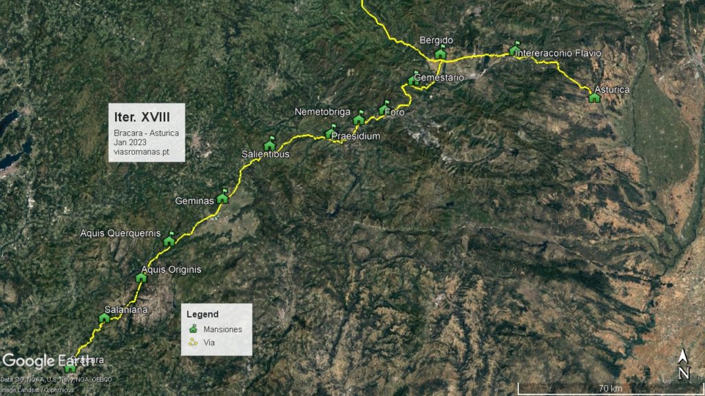
The problem is centred in the distances between stages that do not match the distance measured on the ground. Summing all the stages we get 218 miles, however the total distance indicated in the itinerary is 215 miles, a divergence never fully explained and which opens the possibility of errors in the miles indicated in one or more stages. If for Aquis Originis and Aquis Querquennis there seems to be no doubt in their location respectively at Banhos do Rio Caldo and Baños de Bande, from there on the doubts grow. According to the Itinerary, the next station, Geminas, is located 16 miles from
Aquis Querquennis but following the route (confirmed by milestones), this value is insufficient to cover the distance between Baños de Bande and Castrum of Torre de Sandiás, the most likely location of this station. This difference is also confirmed by the milestones found nearby since the milestone of Casasoá indicates 73 miles to Braga, a value in accordance with the milestone count. Thus, we would have to correct the 16 miles indicated for this stage for the 17 measures, making a total of 70 miles to Braga.
The location of the following stations is still under great discussion and no consensual solution is in sight. The proposals of Rodriguez Colmenero (et al. 2004) continue to be the basis of what is written on the subject, maintaining the great confusion installed by launching the theory of different values of mileage that supposedly would be used in different stretches of track, depending on the characteristics of the terrain. This was an attempt to justify the various inconsistencies in the proposals presented, creating a deadlock that remains to this day. Later studies came to dismantle this thesis because the only measure verified on the ground corresponds to the so-called “classic” mile, which is around 1500m.
The clear excess of miles in this itinerary, making it necessary to place two stations very close to each other seemed to make the hypothesis of an error in the miliary counting much more likely.
Continuing the route, Salientibus could be in Vigueira de Abaixo (milestones), 18 miles from Geminas (Torre de Sandiás). Consequently, the next station, Praesidio, would be 18 miles ahead, distance which puts this station in Pobra de Tivres, in a strategic place since it was located between the two main Roman bridges, Ponte Navea and Ponte de Bibei (this one still standing!). After crossing the Bibei river, the route ascended to Larouco and from here, headed to Ponte da Cigarossa (also presenting Roman foundations) where Nemetobriga should be located. The recent discovery in 2022 of a milestone of Nero during works near the bridge, reconfirms the passage of the XVIII Itinerary in this place, which is exactly 120 miles away from Braga (meanwhile the milestone was placed in its probable original location at the bridge entrance).
The main problem lies in the next stage, between Nemetobriga and Foro, for which the Itinerary indicates the distance of 19 miles. However, this value seems too high since adding up all the stages until Bergido (undoubtedly located in Castro Ventosa, west of Cacabelos), we get a total of 50 miles (19+18+13), a value that greatly exceeds the distance between Cigarrosa Bridge and Castro Ventosa which is no more than 39 miles.
This difference of 11 miles must be justified by an error in the Itinerary. Now, analyzing the intermediate distances, everything indicates that this error can only be in the Nemetobriga to Foro leg that should be corrected to 8 miles (possible confusion between the numerals XVIIII and VIII). In this way, we reach the Foro station near the so-called villa of San Salvador in the place of Proba in Barco de Valdeorras. The site was excavated and then reburied, but it was found to be a vicus viarum, located next to the via, where a milestone also appeared. A votive inscription placed by a member of the VII Gemini Legion reinforces the passage of the Roman road here.
The distances to the following stations seem to be correct, with Gemestario located 18 miles from Foro and 13 miles from Bergido, a position which corresponds to the Alto da Portela de Aguiar in a mountain range called Sierra de Encina da Lastra, which defines de geographical border between the provinces of Galicia and Asturias. From here, the route descends to the valley of the river Sil and continues straight up to the Ventosa castrum, where it joins the Lugo-Astorga road. Here it curves eastwards for another twenty miles to Interamnio Fluvio or Intereraconio Flavio (different spellings of the same station), most probably located close to Bembibre, next to the junction of the rivers Noceda and Boeza, a position that fits a name as “Interamnio Fluvio“.
From Bembibre the route follows more 30 miles up to Astorga, passing Ribeira de Folgoso, Torre del Bierzo, San Juan de Montealegre, Manzanal del Puerto and Brimeda, a route marked by several milestones.
Thus, the survey of the route and the milestone sequence points to the following proposal for the location of the stations: Salientibus (Vigueira de Abaixo, XVIII), Praesido (Pobra de Trives, XVIII), Nemetobriga (Ponte da Cigarrosa, XIII, 120 miles to Braga), Foro (VIII, Pobra de Barco), Gemestario (Alto da Portela de Aguiar, XVIII) and Bergido (Castro Ventosa, Cacabelos, XIII), See route description here.