Despite being a strongly Romanised region, the road network in antiquity in the Algarve region remains with several open questions. The different proposals that have been put forward, often incompatible with each other, do not allow to draw a general picture of the network. The first researcher to tackle the problem in a scientific way was Estácio da Veiga at the end of the 19th century, initiating a series of studies based on the archaeological evidence he was compiling and publishing during his field surveys. By definitively proposing the location of Balsa in the area of the present-day Quinta de Torre de Aires (instead of Tavira) and of Baesuris in the sideric settlement of Castro Marim (instead of Ayamonte), Veiga clarified many of the doubts that had remained about the location of these settlements since the initial proposals launched by André de Resende in the 16th century (Veiga, 1886). In turn, the location of Ossonoba in Faro was only definitively established in the mid-20th century by Abel Viana, dispelling another of Resende’s misconceptions, who associated Ossonoba with the monumental remains of the villa of Milreu in Estoi (Resende, 1593: fl.189; Viana, 1952: 250-285)..
According to the soc-called “Antonine Itinerary” (IA, 425.6), these three port settlements on the Algarve coast were connected by a road, presumably running parallel to the coastline (Veiga, 1886). At the beginning of the 20th century the only known milestone in the Algarve (IRCP 660) was found probably in situ near a place called Bias do Sul (Olhão) and then re-used in a water noria, a find which seemed to confirm a route close to the coast (Mascarenhas, 1967: 3-11) . Fernandes Mascarenhas also mentions “traces of constructions, such as thick foundations and pieces of very thick tiles and bricks” next to the milestone.
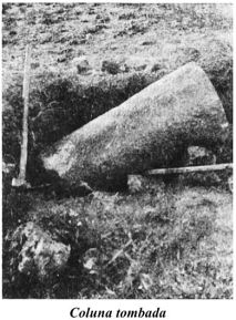
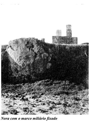
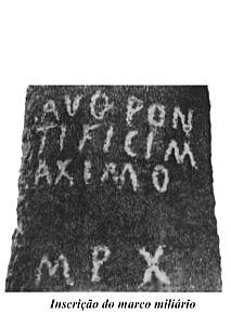
Photos of the milestone when it was discovered, later reused in a water noria and detail of the epigraph with the letters revived indicating 10 miles (in Mascarenhas, 1967).
Mascarenhas also proposed that the 10 miles indicated in the milestone (M.P. X) were referring to the city of Faro which is in fact the distance between these points. SInce then, most researchers followed this proposal and traced a route through Bias along the (Mantas, 1990: 184, 1997; Silva, 2002, 2005 and 2007; Rodrigues, 2004; Maia, 2006). This landmark is currently on display at the Olhão Municipal Museum after many years in the Moncarapacho Parish Museum.
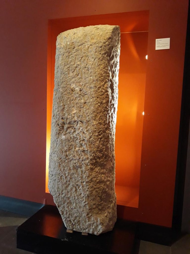
Milestone in Olhão 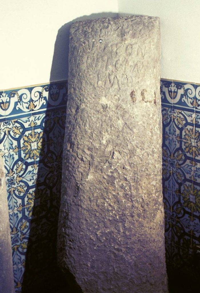
Milestone in Moncarapacho 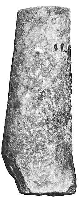
Milestone in Mantas, 1997
Despite the apparent consistency of the arguments presented, actually there is no evidence of any east-west road passing through this location, a fact that Mascarenhas gets around by supposing the road is under the current N125 (Mascarenhas, 1967: 9). If this was the case the track would have to follow north from the villa of Quinta do Marim towards Faro. However, all indications are that this route is a modern construction as it crosses several mats that at that time penetrated well inland through the streams of Ribeiro do Tronco and Ribeira de Marim. This way, from Balsa, the roads to Faro had follow a more inland route to avoid these mats, passing through Moncarapacho and Ponte Velha de Quelfes towards Faro (see itinerary).
But if the milestone of Bias was not marking this route along the coast, then it belonged to another “via”, but which one? To the south, we have the ocean, so the road could only run north, perpendicular to the route to Faro. And in fact, the column was found next to an ancient path called “Canada de Bias” that runs from Bias to the north. This route, mostly still used today as a rural path, goes in the direction of Moncarapacho. It then goes through São Brás de Alportel to reach the town of Querença, a major road-junction of the region. Here, it joins with the main route connecting Faro to the port of Alcácer do Sal (Salacia), passing in the pre-Roman settlement of Castro da Cola (Ourique), presumably the location of Arannis, a road station mentioned in the Antonine Itenerary 60 miles from Faro.
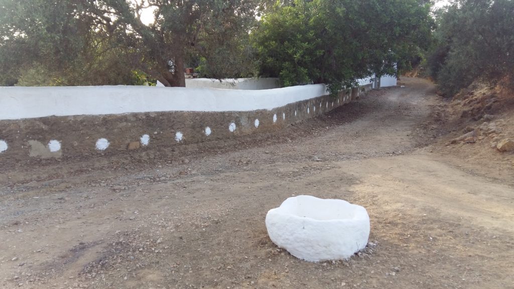
Very close to the place where the milestone appeared, there is a road junction next to Poço de Bias which could be the original site of its implantation, since this place is located around 3 miles from Moncarapacho. In this junction, next to rural house of Quinta do Neto, there is an animal trough and a well in direct connection with the ancient road (see photos). This assumption is also confirmed by the fact that the first mile falls on the ancient christian temple known as the Ermida of São Sebastião dos Matinhos (or do Bitoito) in Belo Romão.
Bias – Mile zero of “Canada de Bias” 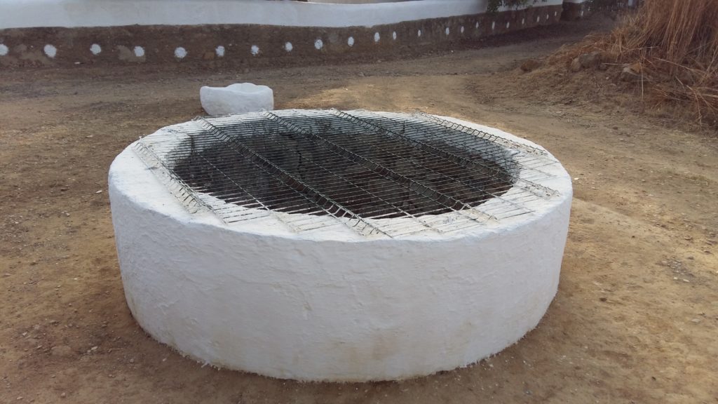
Bias – The well on mile zero
From Moncarapacho, the road keeps going north reaching the Cerro do Moinho de Pereiro (m.p. VI), from where it turns northwest towards São Brás de Alportel, passing near Poço do Cavaleiro (m.p. VIII) and Desbarato, located 9 miles from Bias. This place is mentioned in the “Crónica da Conquista do Algarve ” as being the place where Dom Paio Peres Correia and his knights spent the night during their incursion to Tavira (Agostinho, 1792), most likely next to the fountain mentioned in a document of the year 1595: “…no primçipio das terras do desbarato domde esta húa fonte por marquo.” (Vinagre, 2006: 53).
It is interesting to note that the name of this place, ‘desbarato’, may according to some authors be a derivation of the Arabic word ‘bis-barat’ which could explain the origin of the enigmatic toponym ‘Bias’. Also the name ‘barat’ could be a corruption of ‘balat‘ which has the
generic meaning of ‘via’ or ‘paved road’. If so, then this toponym ‘bis-balat’ could be read as ‘the paved road to Bias‘, i.e., a direct reference to via passing in Desbarato.
The road went on to Fonte da Mesquita, reaching the tenth mile near a small hill called Cerro da Mesquita. The road is apparently mentioned in a document also of 1595 as the “caminho do Chamso a dar no Ribeiro da Mesquita […] e dahi vai a partisão por ribeiro da fonte da mesquita que ele muito antiga“; Vinagre, 2006:55).
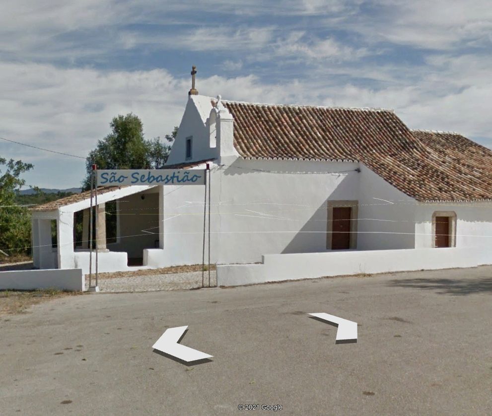
Chapel of San Sebastian – m.p. I 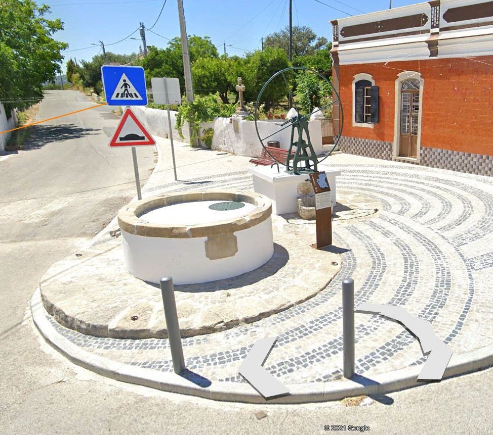
Fonte da Mesquita (“mosque fountain”) – m.p. X
Several small Roman rural structures are known in the area, probably related to this road station, but there is no sign of any settlement nearby. It is therefore possible this stop was related to some place of worship, presumably a sanctuary, and possibly a predecessor of the “mesquita” (mosque) stated in its toponym.
The track goes on through São Brás Alportel, passing slightly north of this town in a place called Campina, another another road station located 12 miles to Bias. From here there was a direct connection to Faro going through Estoi (also 12 miles long), but the route we are describing keeps going to northwest towards Querença, a road station on the route linking the Algarve to Alcácer do Sal. The usefulness of this connection to Bias is better understood when we analyse this route in the opposite direction. If you arrived at Querença coming from the north, you could go to Faro through Loulé or follow the road described here as “Canada de Bias”, connecting Querença to the ancient coastal area in Bias.
The usefulness of the connection to Bias is better understood when we analyse this route in the opposite direction. If you arrived to the Algarve through Querença, you could either head to Faro via Loulé or follow the “Canada de Bias” to the coast, crossing at Moncarapacho with the coastal road from Faro to Castro Marim, and then on to Balsa and Tavira. Now, the existence of this route from Querença to Bias could only be explained by assuming that Bias was a sea port during the Roman period. In 1841, João da Silva Lopes wrote: “At the site of Bias we have found many graves, all with a stone at the head, another at the feet, and two in the middle” (Silva Lopes, 1841: 372). Mascarenhas also mentions “the discovery of immense construction materials of Roman type, very close to the sea” (Mascarenhas, 1967: 4). Just 500 m from the milestone, facing the ancient coastline there are still remains of a quadrangular fortified tower (named «Torre de Bias do Sul 2») that may be related to this harbour, despite current dating pointing to no early than the 11th century.
As such, the milestone would mark the distance counted from Bias’s port to the road station in Cerro da Mesquita, a place that matches the 10 miles engraved in the milestone. The importance of this station derives from the fact that it is located exactly halfway along this route, as the distance from here to Querença it is also 10 miles, making a total of 20 miles, a module that is in fact repeated on the route from Castro Marim to Faro with a total of 40 miles, with Tavira as an intermediate point, given that it is 20 miles both from Faro and from the right bank of the Guadiana near Castro Marim (and not Balsa, only founded in the 1st century) . This surprising concordance in distances between stages cannot be just a coincidence, but rather to a deliberate act of structuring the network with standardised distances.
In this context, it is important to recover the old discussion about the location of the Statio Sacra, a place mentioned in the geography book of the so-called Anonymous of Ravenna, apparently located by this author between Balsa and Ossonoba (Rav. IV.43). In 1877 Estácio da Veiga proposed its location in Quinta do Marim (Veiga, 1887: 390-391) an hypothesis highly disseminated, but that was never consensual among researchers (Mantas, 1997: 315). The name suggests some kind of rural sanctuary, but only a private mausoleum was found here, most likely belonging to the near by Roman villa (Graen, 2007: 277). In turn, Leite de Vasconcelos associated Statio Sacra with the Promontorium Sacrum (present-day Cabo de São Vicente), placing it in roman finds of Martinhal beach (Vasconcelos 1905:198), actually a amphora-producing factory ; more recently it was associated with Moncarapacho (Silva, 2002: 47) while Mantas proposed the villa of Milreu (Mantas, 2008: 247); however, none of these proposals were ever confirmed. Moncarapacho would indeed be a good candidate given that it is a road station of the route from Ossonoba to Balsa, 10 miles from Tavira and to Faro.
However, it also possible that the Statio Sacra is not related to the Ossonoba-Balsa road, but to this road from Bias to Querença. Based on the data currently available, we cannot exclude its location at any of the respective stations (namely, Bias, Moncarapacho, Mesquita, Alportel and Querença), but the fact that the milestone indicates 10 miles cannot be ignored, suggesting that it marked the distance to a relevant location, i.e., the distance from the port of Bias to some road station with a more inland location.
If this were the case, then the Statio Sacra would be located in Fonte da Mesquita or its proximities, referring to an eventual rural sanctuary, but for the moment this is merely a working hypothesis, since the inverse is also possible, that is, the name ‘statio’ was also applied to name a ‘small port’, an interpretation that fits perfectly to its location in Bias do Sul. In turn, the epithet ‘Sacra‘, in this context, may have the meaning of ‘imperial’, suggesting a consecration of the place to the imperial cult (Tovar, 1976: 206). The archaeological context also points in that direction, namely an inscription consecrated to Augustus by an administrator (‘dispensator’) da vizinha cidade de Balsa (IRCP 74), as well as the milestone itself that was most likely also placed during the Julio-Claudian dynasty, that is, sometime between 27 BC and 68 AD. (Encarnação, 1984: 720). The foundation of Balsa in this period (possibly as a result of the progressive silting up of the port of Tavira, just 6 km away), may have implied a reform of the road system, of which the Statio Sacra and the milestone would echo.
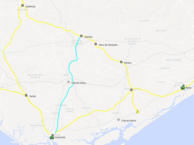
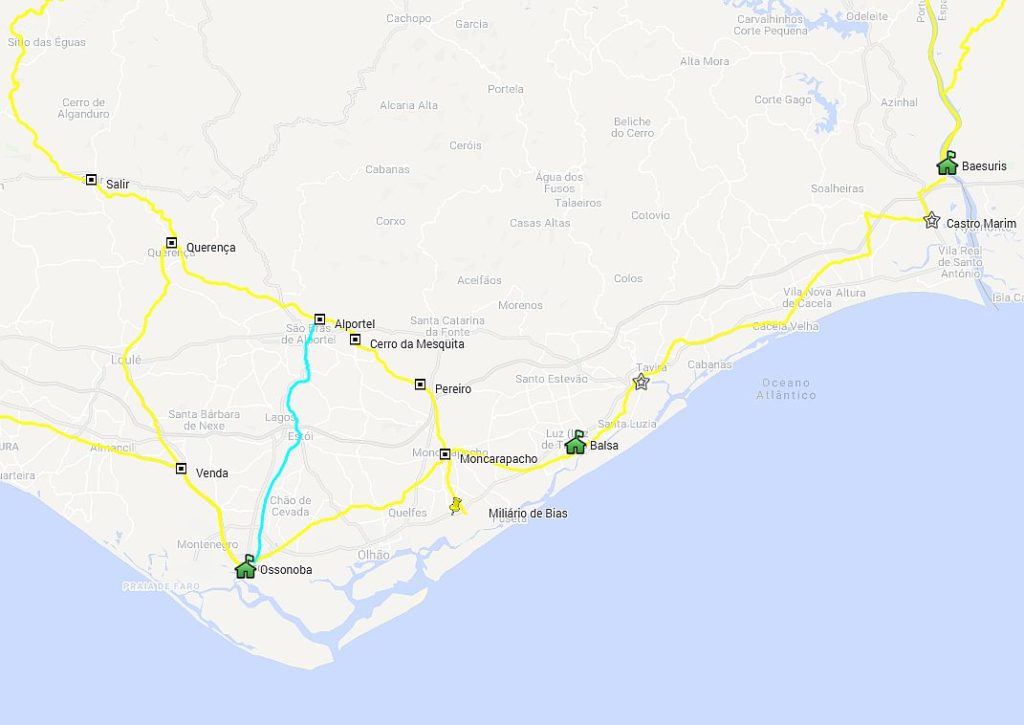
But regardless of the true location of the mysterious Statio Sacra, there seems to be no doubt about the importance of this route in the overall road network during the Roman period (and before and after), allowing the solve many of the inconsistencies of the previous proposals to be solved and proposed a revised map of the ancient road network in the eastern Algarve (see map). The description of these routes can be found on www.viasromanas.pt and their tracing on the Map of Vias (from version 4.4 on).
Coordinates of some key points on this route:
Mile zero at Bias: 37.049608, -7. 776432
Chapel of St Sebastian (m.p. I): 37.060587, -7.785435,
Desbarato (m.p. IX): 37.143647, -7.842630
Fonte da Mesquita: 37. 146892,-7.854586
Cerro da Mesquita (m.p. X): 37.149943,-7.855184
Bibliography:
AGOSTINHO, Frei Joaquim de Santo (1792) – “Sobre huma chronica inédita da conquista do Algarve”, Memórias de Litteratura Portuguesa, Real Academia das Ciências, Lisboa, Tomo I, p.74-97.
ANONYMOUS OF RAVENA (c. 7 AD) – “Ravennatis Anonymi Cosmographia et Guidonis Geographica”. Berlin: M. Pinder / G. Parthey (1860).
ENCARNAÇÃO, José d’ (1984) – “Inscrições Romanas do Conventus Pacensis: subsídios para o estudo da romanização (IRCP)”. Coimbra: Universidade.
GRAEN (2007), Dennis – “O sítio da Quinta de Marim (Olhão) na época tardo-romana e o problema da localização da Statio Sacra”. In RPA 10, 1, 275-288.
MAIA, M. (2006) – “De Baesuris a Pax Ivlia por Aranis”. São Brás de Alportel: Actas das I Jornadas «As Vias do Algarve», 46-53.
MANTAS, Vasco G. (1990) – “As cidades marítimas da Lusitânia”. Paris: CNRS (Coll. Maison des Pays Ibériques; 42), p. 149-205.
MANTAS, Vasco G. (1997) – “As civitates: Esboço da geografia política e económica do Algarve romano”, in Noventa séculos entre aserra e o mar, Lisboa, 283-309.
MANTAS, Vasco G. (2008) – “A rede viária romana em Portugal: estado da questao e perspectivas futuras”. Anas, 21-22, 2008-2009, 245-272.
MASCARENHAS, J. Fernandes (1967) – “De Ossónoba a Balsa”. Col. Por Terras do Algarve – Tavira: Ed. Autor, 7-25.
RESENDE, André de (1593) – “As Antiguidades da Lusitânia”. Lisboa: Edição «Fundação Calouste Gulbenkian», 1996. Introdução, tradução e comentário de R. M. Rosado Fernandes.
RODRIGUES, Sandra (2004) – “As Vias Romanas do Algarve”. Faro: CUP-UAlg/CCRA.
SILVA, L. Fraga da (2002) – “A região de São Brás de Alportel na Antiguidade”. Tavira: Campo Arqueológico de Tavira.
SILVA LOPES, J. B. da (1841) – “Corografia ou Memória económica, estadística e topográfica do Reino do Algarve”. Lisboa: Academia Real das Ciências.
TOVAR, Antonio (1976) – “Iberische Landeskunde – Die Völker und die Städte des antiken Hispanien”, Part II, Vol. 2. Lusitanie. Baden-Baden.
VASCONCELOS, J. Leite de (1905) – “Religiões da Lusitânia”. Vol.pro 2. Lisboa: INCM (reed. de 1989).
VEIGA, Estácio da (1866) – “Povos Balsenses: sua situação geographico-physica indicada por dous monumentos romanos recentemente descobertos na Quinta da Torre d’Ares…”. Lisboa: Livraria Catholica.
VEIGA, Estácio da (1887) – “Antiguidades monumentais do Algarve Tempos prehistóricos”. Lisboa: Imprensa Nacional, Vol. 2.
VIANA, Abel (1952) – “Ossónoba. O problema da sua localização”, Revista de Guimarães 42, 250-285.
VINAGRE, Augusto et al. (2008) – “Toponímia de S. Brás de Alportel”. Trabalho com alunos da Escola EB2,3 de S. Brás de Alportel in “dos Algarves”, 17, 52-58.
WESSELING, Petrus (1735) – “Vetera Romanorum Itineraria, sive Antonini Augusti Itinerarium, Itinerarium Hierosolymitanum, et Hieroclis Grammatici Synecdemus”. Amsterdam.