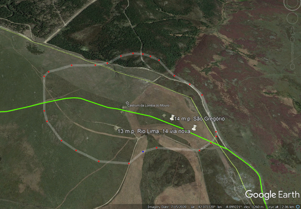
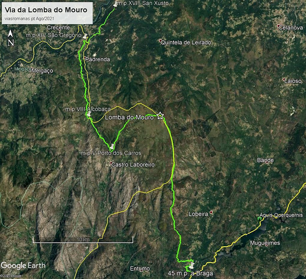
With regards to the current excavation at the Roman military camp of Lomba do Mouro (Castro Laboreiro), whose preliminary results point to the conquest period of the peninsular northwest (video), I tried to identify the possible route of the track that crossed the Roman camp, situated on the heights of the Laboreiro mountain range, present-day Galicia/Portugal border (apparently absent from the scientific literature). In fact, if we extend the track southwards, following the mountain’s festo line, we will find the new track, crossing the Lima river near the village of Torno (Lóbios). This route would be a northern derivation of the via nova between Bracara and Asturica, crossing the Lima at a meander of the river called Retorta, 45 miles away from Braga. It then ascended the slope up to the Ermida de San Benito (perhaps through Lama and Ferreiros), continuing afterwards through the Serra de Laboreiro up to the Roman camp, making up 13 miles from the Lima, the usual distance between road stations.

The compound still bears the remains of its 2.2 m thick wall, enclosing an area of over 20 hectares (Costa-García, Fonte and Gago, 2019: 33). The existence of this camp implies that the route would have continued to Galicia, but its route northwards from the camp does not seem feasible, presenting a very rugged terrain, where passage is very difficult. Thus, it is more likely that the track would have made an inflection towards Castro Laboreiro (perhaps through Alto da Picota, Queimadelo, Falagueiras, Coriscadas e Porto de Carros), and from there going north again, through Porto de Asnos and through the valley of the Trancoso River to São Gregório, where it entered Galicia. Its route should correspond to the path which passes through the road names Vido, Portelinha and Porteiro or Porto de Cavaleiros (former “Porto de Asnos”), continuing through Alcobaça, A-da-Velha, Campo do Souto, Sobreira and Cristoval as far as São Gregório, going down from here to cross the Trancoso river at the so-called Ponte Velha or Ponte Barxas, an ancient entrance gate into Galician territory. The route could then follow alongside the toponym Vendas towards the Ermida de San Xusto (Trado), 18 miles from Lomba do Mouro, possibly heading towards Ourense, but its final destination is still uncertain.

The strategic importance of this penetration route for the Roman armies of the initial phase of the conquest seems to be attested by the great size of the military enclosure, almost totally surrounded by a solid wall, which could only be justified for a route of the greatest military importance. Its location, halfway between the Lima and Minho rivers (13 miles to the Lima and 14 to São Gregório), allowed it to exert total control over this passage.
Although some authors felt that there should be a northward derivation of the new route, its layout continued to raise many doubts. The identification and characterisation of this important military settlement thus provides a strong argument for the identification of this road axis and its articulation with the major routes in the region.

There doesn’t seem to be any doubt about the antiquity of this path, given that the Roman settlement sits on a vast field covered with megalithic funerary monuments that testify to its use since very early times. Despite the abandonment of the camp after the conquest of this territory, the track would have remained in use until the high-medieval period, during which the dividing line between Portugal and the current Galician territory was formed. The fact that the route crossed both sides of this division may have contributed to its decline, as it was now cut by the border line.
The “Portuguese” part, connecting Castro Laboreiro to São Gregório, through the referred
“Porto de Asnos” remains in use as the main entrance to Galicia, as referred to in various medieval documents, and is considered a strategic passage for the defence of the Entre Lima and Minho territory. Following a tax dispute with the neighbouring Castle of Melgaço, this stretch of the road was closed to traffic in 1361, forcing all travellers to go to and from Galicia via Melgaço, which also contributed to its oblivion:
“To avoid paying this toll, merchants who carried their goods from Galicia, and vice versa, opted for the passage of the Porto dos Asnos, joint place of the parishes of Lamas de Mouro and Castro Laboreiro. To avoid this tax evasion, by letter written in Elvas, on 28th May 1361, D. Pedro I forbade this path, forcing the merchants to pass through Melgaço”. (in Domingues, 2003: 11)
The growing disuse of this route may have contributed to its relative oblivion in the context of Roman roads, but identification of what seems to be “the largest and oldest” Roman military camp between the 2nd and 1st centuries BC. (Costa-García, Fonte and Gago, 2019: 33), located precisely halfway between the rivers Lima and Minho, constitutes a strong argument to validate the existence from this route that was surely one of the lines of penetration lines of the Roman army during the period of conquest in the northwest of the Iberian Peninsula.
Bibliography:
COSTA-GARCÍA, J.M.; FONTE, J.; GAGO, M.; (2019) – “The reassessment of the Roman military presence in Galicia and Northern Portugal through digital tools: archaeological diversity and historical problems”, Mediterranean Archaeology and Archaeometry 19, 3, (2019), p. 17-49 https://zenodo.org/record/3457524
DOMINGUES, José (2003) – “O Foral de D. Afonso Henriques a Castro Laboreiro. “Ádito” para o debate”. Porto, 2003, [placed online 6 May 2013].
http://www.academia.edu/3470740
romanarmy.eu – Collective research on the Roman military presence in the northwest Iberian Peninsula https://www.youtube.com/watch?v=fXGZVPHf3Oc&ab_channel=romanarmy.eu