Tag Archives: Alva

The crossing of the River Alva at the Mucela Bridge

One of the main itineraries that crossed the portuguese territory had origin in the city of Conímbriga, crossing the «Beira Alta» region towards the river Douro, passing in Bobadela, Celorico da Beira (where it crosses the Mondego River), and through the territory of the Civitas Aravorum (Marialva), linked to important crossings of the Douro, one in Quinta de Vesúvio/Sra. da Ribeira and another on Monte Meão/Foz do Sabor (and not for Salamanca as had been said).

This itinerary has been associated to the so called “Estrada da Beira” (Beira Road) that starts in the city Coimbra and links to Celorico da Beira, but the direction of this route clearly indicates that its origin was in Conímbriga and not in Coimbra. A possible branch connecting to Coimbra, although not impossible, does not seem feasible, since the derivations of the route connect not to Coimbra but to fluvial ports in the Mondego (namely Porto da Raiva and Penacova). Although there are tracks on the other bank, these seem to be heading northwest and not towards Coimbra, which further weakens this hypothesis. Inevitably, these tracks end up crossing the route coming from Viseu towards Coimbra, and thus can follow this way that city, but the various inflections in the way are not consistent with the existence of an independent track linking Coimbra to Bobadela.

If there are doubts about the final destinations of the road, the place where the road crossed the River Alva is unanimous, pointing to the area of «Ponte da Mucela», a traditional crossing point since the Middle Ages. In the book Monarquia Lusitana, Fray Francisco Brandão transcribes an inscription that was placed on the medieval bridge, commemorating its construction in 1295, during the reign of King Dinis. However, the identification of some Roman stones that were reused in the medieval construction supports the hypothesis of an earlier Roman bridge, perhaps further downstream, near the Roman settlement of Moura Morta, where the crossing is much easier.
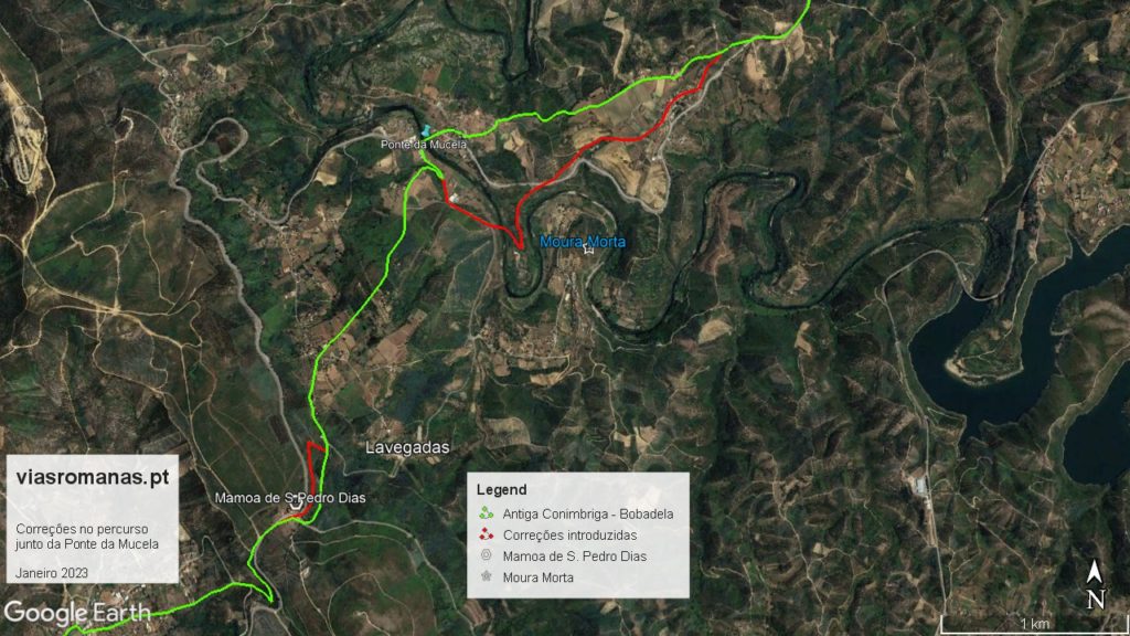
Changes introduced to the route Via Conímbriga – Bobadela at the crossing of the Alva River (red line), near the Roman settlement of Moura Morta and crossing of «Serra do Bidueiro» near the megalithic «mamoa» of S. Pedro Dias.

The settlement is located on a meander of the River Alva, which surrounds the settlement on all sides but the southern side, from where the site was accessed. However, the strong cliffs on the other bank make it impossible to cross at the base of the settlement. However, between this place and the bridge, there is a more favourable area to cross the river, taking advantage of a hump that exists there to start the ascent of the hillside in gentle steps. In fact, the passage through this area might not even require the construction of a bridge, in which case, the Roman ashlars  could have come from the village of Moura Morta itself, which is only about 1 km from the current bridge.

But independently of the question if the existence of a Roman bridge, everything points for the crossing here of the river for the reasons explained above and also because this tracing is in line with the mile sequence between Conímbriga and Bobadela. In fact, the distance from Conímbriga to the Alva River through the proposed route totals 29 miles (typical value between stages), and the 27th mile points to the top of the mountain gateway of Serra do Bidueiro, next to megalithic monument called «Mamoa of S. Pedro Dias» (a pilgrimage to this site takes place everyear), showing once again the great antiquity of this route, at least as a footpath.

This correction also allows us to match the sequence of miles with the only known station in this route, located in Eira Velha (unfortunately recently destroyed by the construction of the Coimbra-Tomar section of the A13 highway, another avoidable destruction of Roman structures next to the road), which is located 22 miles from Rio Alva and seven miles from Conímbriga. This track continued westwards until the town of Soure (eventually a river port of the Mondego), where a milestone was found.

Regarding milestones, there are only three on this route, all of them found near Seia, at the crossing with another major road, the route from Viseu to São Romão castrum (c. Seia), so we do not know for sure which of the two routes was marked by milestones.

The only one that still keeps part of the inscription is from Imperor Maximiano, indicating XXI miles, a distance compatible with Bobadela and Celorico da Beira, but which seems more appropriate to the latter, in this case marking the distance to the Mondego River. It is currently located in the garden of a rural tourism house in Paços da Serra. Recently, another milestone (anepigraphic) was identified near the Santa Comba cemetery, which is most probably in situ, and is therefore decisive to adjust the milestone sequence. The third one was identified nearby, in the village of Vila Chã, and it was reused as support of a balcony of a house, whose morphology and proximity to Santa Comba supports the hypothesis that it is in fact another milestone of this route.

Returning to the crossing of the Alva river at Mucela, the Moura Morta site does not have any sign of a previous Iron Age occupation, which means that it was established by the romans, eventually to control this passage (possibly a statio). However, until the settlement is excavated, nothing more can be added.

O cruzamento do Rio Alva na Ponte da Mucela

Um dos grandes itinerários que cruzava o nosso território tinha origem em Conímbriga e cruzava a Beira Alta rumo ao Rio Douro, seguindo por Bobadela, Celorico da Beira (onde cruza o Mondego), seguindo depois por Mêda rumo a duas importantes travessias do rio Douro, uma na Quinta de Vesúvio/Sra. da Ribeira e outra no Monte Meão/Foz do Sabor (e não rumo Salamanca como é comum afirmar-se).

Este itinerário tem sido associado à chamada “Estrada da Beira” que partia de Coimbra rumo a Celorico da Beira, mas a directriz deste trajecto aponta claramente para que sua origem em Conímbriga. A eventual ligação a Coimbra não parece viável no terreno, podendo o trajecto ser fluvial, nomeadamente a partir do Porto da Raiva ou Penacova. Ainda que haja caminhos na margem direita do Mondego, estes parecem dirigir-se a noroeste e não a Coimbra, o que fragiliza ainda mais a hipótese de uma via terrestre até essa cidade.

Se existem dúvidas no destino final da estrada, o local onde estrada cruzava o Rio Alva recolhe unanimidade, apontando para a área da Ponte da Mucela, tradicional ponto de passagem desde a Idade Média. No Monarquia Lusitana, o Fr. Francisco Brandão transcreve uma inscrição que estava colocada na ponte medieval, comemorando a sua construção no ano de 1295, durante o o reinado de D. Dinis. No entanto, a identificação de alguns silhares romanos reutilizados na construção medieval, permitia sustentar a hipótese de uma ponte romana anterior, talvez mais a jusante, próximo do povoado romano da Moura Morta, onde a travessia é bem mais facilitada.

Alterações introduzidas no traçado da Via Conímbriga – Bobadela na travessia do Rio Alva (linha vermelha), junto ao povoado romano de Moura Morta e a Serra do Bidueiro junto da mamoa de S. Pedro Dias.

O povoado assenta num meandro do rio Alva que rodeia o assentamento por todos lados menos do lado sul, por onde se acedia ao local. Contudo, as fortes arribas na outra margem inviabilizam a passagem junto ao assentamento. No entanto, entre este e a ponte, existe uma zona mais favorável ao cruzamento do rio, aproveitando depois uma lombada que ali existe para iniciar a ascensão da encosta em suaves patamares. Aliás a passagem neste local poderia até não exigir a construção de uma ponte, sendo que nesse caso, os silhares romanos poderão ter vindo do próprio povoado de Moura Morta que dista apenas cerca de 1 km da ponte actual.

Mas independentemente da questão se haveria ponte romana ou não, tudo indica que a travessia seria neste local pelas razões apontadas e também porque este traçado vem acertar a marcação miliária entre Conímbriga e Bobadela. De facto, a distância medida de Conímbriga ao Alva pelo percurso proposto totaliza 29 milhas (valor típico entre etapas), sendo que a milha 27 corresponde ao alto da portela da Serra do Bidueiro, onde se regista um monumento megalítico, a mamoa de S. Pedro Dias (local de romaria em torno da capela ali existente), evidenciando mais uma vez a grande antiguidade deste trajecto, pelo menos como caminho de pé-posto.

Esta correção permite também acertar a marcação miliária com a única paragem comprovada arqueologicamente no percurso entre o Alva e Conímbriga, a estação viária romana da Eira Velha (infelizmente recentemente destruída pela construção do troço Coimbra-Tomar da A13, em mais um atentado perfeitamente evitável), localizada a 22 milhas do Rio Alva e a sete milhas de Conímbriga. Esta via continuava para ocidente até Soure (possível cais fluvial do Mondego), onde apareceu um miliário.

A propósito de miliários, nesta via não se contam mais que três marcos, todos identificados nas proximidades de Seia, assinalando, aliás, o cruzamento com outro grande eixo viário, a via oriunda de Viseu que ligava ao Castro de São Romão (c. Seia), criando dúvidas sobre qual destas estradas seria assinalada por estes marcos.

O único que ainda mantém parte da epígrafe é de Maximiano e indicada XXI milhas, distância compatível com Bobadela e, mais ainda, com Celorico da Beira, que nesse caso, indicaria a distância ao Rio Mondego. No entanto, não podemos excluir a hipótese deste marco indicar a outra rota para Viseu, sendo que as 21 milhas são compatíveis com a distância daqui à travessia do Rio Dão na Ponte Romana de Alcafache. Actualmente encontra-se deslocado no jardim de uma casa de turismo rural em Paços da Serra. Recentemente foi identificado uma outro miliário (anepígrafo) junto do cemitério de Santa Comba que estará muito provavelmente in situ pelo que é decisivo par ao acerto da marcação miliária desta via. O terceiro foi identificado ali próximo, em Vila Chã, reutilizado como suporte de uma varanda de uma casa da aldeia, cuja morfologia e proximidade a Santa Comba sustenta a hipótese de se tratar de outro miliário.

Voltando à travessia do Alva na Mucela, o sítio da Moura Morta não apresenta ocupação da Idade do Ferro pelo que se trata de uma estabelecimento de fundação romana para apoio e controlo da via (eventualmente uma statio). No entanto, enquanto não houver um escavação do povoado nada mais se pode acrescentar.