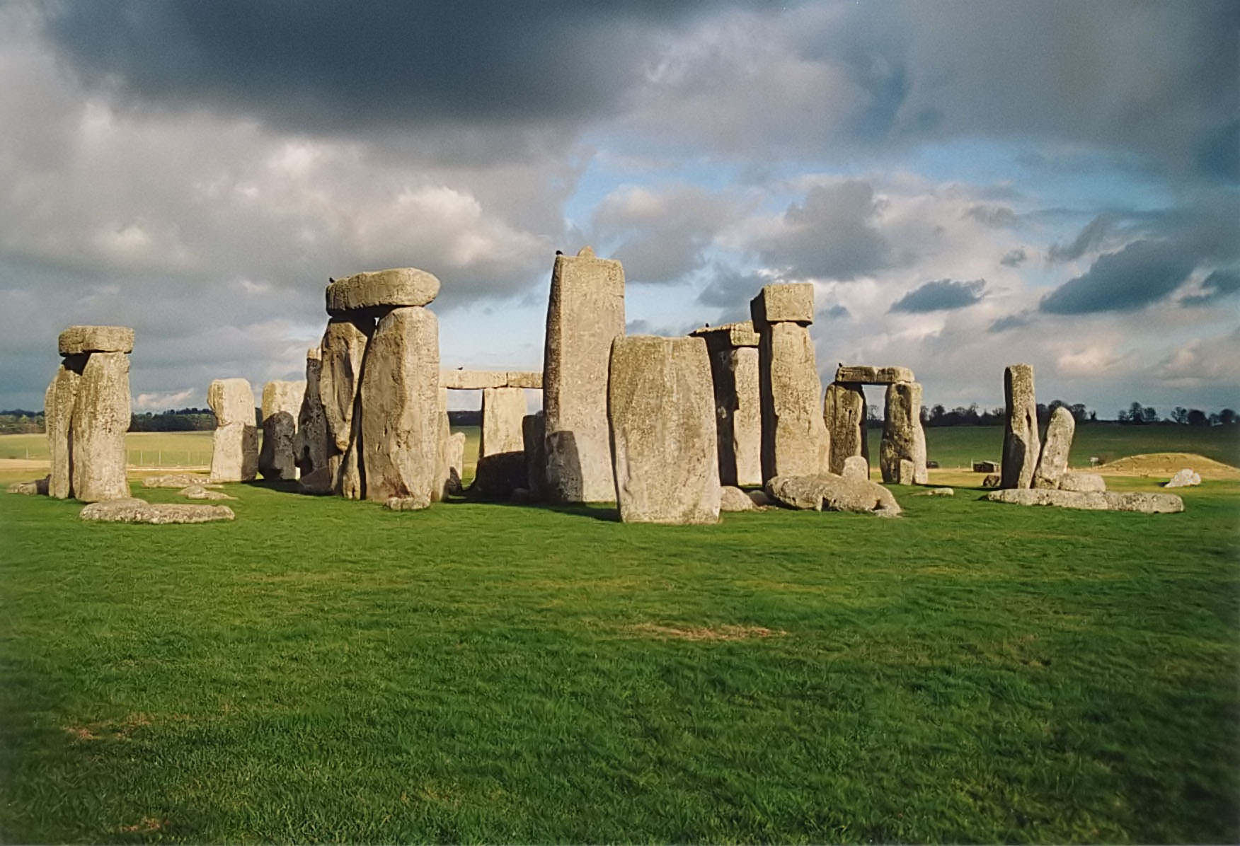
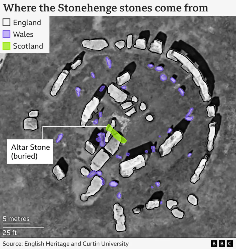
The stone circle at Stonehenge is one of the most discussed monuments in the world. Its uniqueness has attracted visitors and triggered their imagination for centuries and more recently it has been raised to one of the main focal points of modern druidism and their ‘astronomical alignments’ interpretations. However, less attention has been giving to the geographical position of the monument and its relation to the ancient road network on the British island. The recent publication (2024) of a paper claiming that the so-called ‘Altar Stone’ placed in the centre of the monument was brought from quarries in northern Scotland (Clarke et al. 2024) relaunched the discussion.
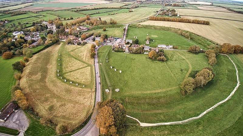
The monument seats on the vast plains of Wiltshire county (England), where there’s a high concentration of megalithic structures scattered across the landscape, by no means less important than Stonehenge, such as the Avebury Stone Circle (Fig. 2) or the Hackpen White Horse (Fig. 5) . This high density reflects the economical power of an organised society tied up by a common culture that is expressed on their monuments.
Thus Stonehenge doesn’t represent a moment in time but a vast period spanning from the Late Neolithic to the Copper and Bronze Ages, from about 3500 BC to 2000 BC. The monument itself is a testimony of this wide time span, since its construction most likely began about 3200 BC (a simple ditch with about 100 m in diameter) while the last interventions on the monument were dated around 1100 BC (‘Blue Stones’ circle brought from Wales).
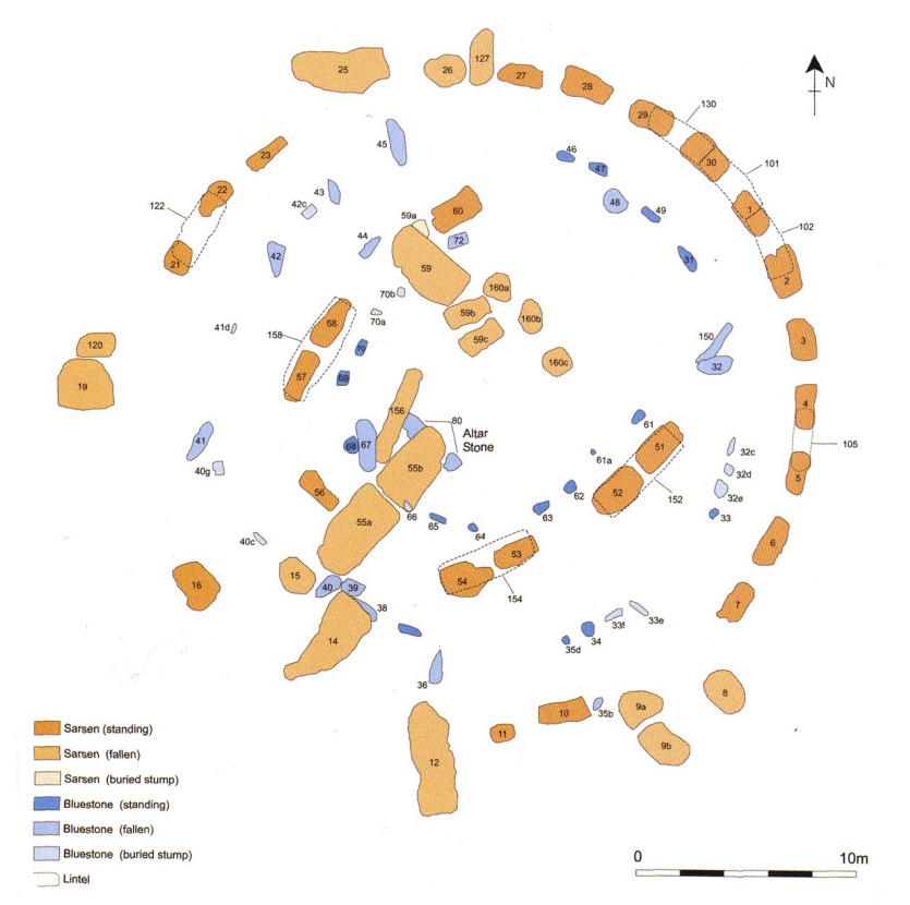
The building materials used on Stonehenge also provide evidence of the vast geographical communities that made contributions to its construction, since some of the stones came from quite distant regions, with the so-called ‘Sarsen Stones’ coming from West Woods quarries (Nash et al., 2020), the so-called ‘Blue Stones’ linked to the quarries on the Preseli Mountains in Wales (Atkinson, 1956; Pearson et al. 2015, 2020), and more recently the so-called ‘Altar Stone’ being linked to the northern part of Scotland (Clarke et al. 2024). The transportation of these stones through such long distances must have been a major effort back then, but also a staggering achievement for these communities, providing evidence of very strong ties of cooperation capable to enlist such a difficult endeavor.
So the question remains unsolved, how could they possible transport such heavy weighted stones for hundreds of kilometers? There are two main hypothesis, one by taking a sea route and other by following an overland route all the way to Stonehenge. The sea route hypothesis seams more suitable for the transportation of heavy goods, but we have no evidence that such method was actually used, and while it can reduce the land part of the journey, it will not eliminate the need to transport the stones from the port to the site by land.
In this post I’ll will advocate for the second hypothesis, i.e., that these stones were brought all the way by land following a already well-established network of routes that crossed Britain. Moreover, the relevance of Stonehenge, reflected on the amount of effort put in its construction, also comes from its strategic position on this ancient network. In fact, Stonehenge seats on the vast plains of Salisbury next to a route coming from the port of Southampton that forks here in three major routes, one to Wales, another all the way to Scotland, thus explaining the provenance of the stones mentioned above, and the third one to northeast, crossing the Thames in Goring and running in the direction of Dunstable, today an historical route called The Ridgeway.
So, Stonehenge was at the interception of these major routes, all running to the main sea port on the southwestern part of Britain, and consequently an important node and stopping point of the island road network. By bringing these stones from such a long distance, these communities were celebrating thee results of their cooperation efforts in creating a road infrastructure capable of connecting distant regions. In this sense, Stonehenge seems to be a monument that evolved in time along with the evolution of the road infrastructure, where most likely, its different construction phases may be a reflection of the different improvements operated on the road network through time.
If true, Stonehenge can be interpreted as a triumphantly monument representing the technical and organisation skills of a society that is moving to agriculture, which leads to production surplus and to commerce. Thus, Stonehenge will be better described not as an “ancient astronomical observatory” of some kind, but a commercial ‘carrefour‘, a way stationasaz at a major road junction. In this sense, the different stones on the monument are symbolical representations of those distant places that could be reached from here by road.
Distances from Stonehenge:
– to Scotland (‘Altar Stone’ quarry), about 750 km
– to Wales (Blue Stones’ quarry), about 300 km
– to West Woods (Sarren Stones’ quarry), about 30 km
– to Southampton’s port, about 45 km.
Another argument supporting this hypothesis is the incredible succession of megalithic monuments along these routes, particularly in the so-called Ridgeway. In this route there’s a continuous marking of road with barrows and other smaller structures along the way (every 1500 m), followed by bigger, Stonehenge-like monuments in the form of stone circles or animal ground depictions as the famous Uffington White Horse.

Another recent paper also claims a strong interaction across these communities, by analysing multi-isotope of the remains of pigs bones at the site, revealing that some of these animals were brought from distant places: ‘This finding demonstrates great investment effort in transporting pigs raised elsewhere over vast distances to supply feasts and evidences the very first phase of pan-British connectivity.’ (Madgwick et al. 2019).
The modern folklore associated with Stonehenge and their mystical interpretations of the site is shadowing the growing evidence pointing to a more pragmatic reason for its construction, i.e., the marking of this road junction and the celebration of its influence in the creation of the network of routes providing ‘pan-British connectivity‘.
Bibliography:
Atkinson, R.J.C. (1956). Stonehenge. London: Hamish Hamilton. https://cir.nii.ac.jp/crid/1130282273050446592
Clarke, A.J.I., Kirkland, C.L., Bevins, R.E. et al. A Scottish provenance for the Altar Stone of Stonehenge. Nature 632, 570–575 (2024). https://doi.org/10.1038/s41586-024-07652-1
Madgwick, R et al. (2019). Multi-isotope analysis reveals that feasts in the Stonehenge environs and across Wessex drew people and animals from throughout Britain.Sci. Adv.5,eaau6078(2019).DOI:10.1126/sciadv.aau6078
Pearson, M.P. (2017). The origins of Stonehenge: on the track of the bluestones. Archaeology International 20:52. DOI:10.5334/ai.353
Pearson, M.P., Bevins, R., Ixer, R., Pollard, et al. (2015). Craig Rhos-y-felin: A Welsh bluestone megalith quarry for Stonehenge. Antiquity, 89(348), 1331-1352. doi:10.15184/aqy.2015.177
Pearson, M.P., Bevins, R., Ixer, R., Pollard, et all. (2020). Long-distance landscapes: from quarries to monument at Stonehenge. In: MEGA-TALKS 2, 19-20 November 2015, Redondo, Portugal, 151 -169 https://eprints.bournemouth.ac.uk/34408/
Nash D.J., Ciborowski T.J.R., et al. (2020). Origins of the sarsen megaliths at Stonehenge. Sci Adv. 2020 Jul 29;6(31):eabc0133. DOI: 10.1126/sciadv.abc013